Search
You searched for:
Start Over
Olalla Creek-Lookingglass Creek Watershed
Remove constraint Olalla Creek-Lookingglass Creek Watershed
« Previous | 1 - 50 of 720 | Next »
Search Results
-
Photo was taken on the Olalla Creek-Lookingglass Creek Watershed
Citation -
97 pp. Tables, references, appendices, maps. The acreage would be divided among 17 units comprising two timber sales, to be authorized individually, and designated as Deep Six (located in Section 27, T. ...
Citation -
5 pp. The units are located in: Section 27, T. 28 S., R. 8 W., W.M.; Sections 7 and 19, T. 30 S., R. 7 W., W.M.; and Sections 1, 11, 13, and 23, T. 30 S., R. 8 W., W.M. Captured July 27, 2007.
Citation -
122 pp. Tables, figures, references, appendices, maps. Density management would be applied to approximately 665 acres of forest stands within the LSR in the Middle Fork Coquille River, East Fork Coquille ...
Citation -
The introduction provides a general description of the watershed in terms of its natural and human-made features, ownership and current land uses, and the communities within the watershed. Information ...
Citation -
64 pp. Tables, references, appendices, maps, figures. Sections 26, 27, T 29 S, R 9 W; Section 33, T 29 S, R 3 W; Section 27, T 29 S, R 3 W; Section 13, T 29 S, R 3 W; Section 22, T 30 S, R 3 W; Section ...
Citation -
7. [Article] Limiting Factors Assessment and Restoration Plan: Olalla Creek Tributary of the Yaquina Estuary
Abstract -- This document provides watershed restoration actions proposed to enhance the Coho Salmon population within the Olalla Creek subbasin in Lincoln County, Oregon. The report contains information ...Citation -
Abstract -- The assessment includes information on past conditions, current conditions of stream function, Riparian zones and wetlands, water quality/quantity, fish populations, stakeholder/landowner perspectives, ...
Citation -
9. [Article] Douglas County : Community wildfire protection plans
221 pp. Includes maps. Each of thirty identified at-risk-areas within the County received its own plan; all are included here in one file in the order in which they are listed in the Introduction, and ...Citation -
10. [Image] Opegrapha rufescens
 Spores; Location: Near Olalla Creek; Substrate: Bark, Fraxinus latifolia; Elevation: 233 meters.
Citation -
11. [Image] Opegrapha rufescens
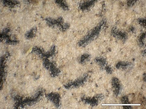 Habit; Location: Near Olalla Creek; Substrate: Bark, Fraxinus latifolia; Elevation: 233 meters.
Citation -
12. [Image] Opegrapha rufescens
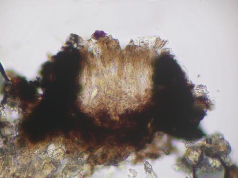 Apothecial section; Location: Near Olalla Creek; Substrate: Bark, Fraxinus latifolia; Elevation: 233 meters.
Citation -
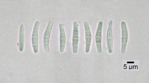
13. [Image] Opegrapha rufescens
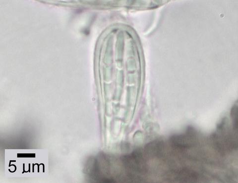 Ascus; Location: Near Olalla Creek; Substrate: Bark, Fraxinus latifolia; Elevation: 233 meters.
Citation -
14. [Article] Fanno/Tryon Creek Watershed Plan: Draft
Abstract -- The Fanno and Tryon Creeks Watershed Plan contains sections on: Introduction to the Fanno/Tryon Creek Watershed Plan, Overview-Tryon Creek Watershed, Habitat and Biological Communities-Background ...Citation -
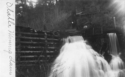
15. [Image] Olalla mining dam
-
89 pp. Tables, references, appendices, maps, illus. The proposed harvest would occur on approximately 150 acres located in Sections 9, 11, 15 and 21 of T. 29 S., R. 7 W., W.M., within the Olalla sixth-field ...
Citation -
17. [Article] Myrtle Creek Watershed assessment and action plan
The introduction provides a general description of the watershed in terms of its natural and human-made features, ownership and current land uses, and the communities within the watershed. Information ...Citation -
18. [Article] West Fork Cow Creek Watershed assessment and action plan
The introduction provides a general description of the watershed in terms of its natural and human-made features, ownership, and current land uses. Information in section 1.2 was compiled from the Oregon ...Citation -
19. [Article] Lower Cow Creek Watershed assessment and action plan
The introduction provides a general description of the watershed in terms of its natural and human-made features, ownership and current land uses, and the communities within the watershed. Information ...Citation -
Abstract -- Aquatic Inventory Project (AIP) habitat surveys for Butte Creek and Morton Creek, New River watershed.
Citation -
21. [Article] Jordan/Alder Watershed Assessment
The Jordan/Alder Watershed is a 2,459-acre watershed located in southwest Oregon immediately west of Canyonville in Douglas County. This watershed--a portion of the O'Shea Creek HUC6, or sixth-field watershed--lies ...Citation -
22. [Article] Meadow Creek Watershed analysis
236 pp. Tables, figures, appendices, maps, references. "The Meadow Creek Watershed (#86) is bordered on the northeast by the Grande Ronde River/Hilgard Watershed (#87), on the southeast by the Upper Grande ...Citation -
23. [Article] Meadow Creek Watershed analysis
236 pp. Tables, figures, appendices, maps, references. "The Meadow Creek Watershed (#86) is bordered on the northeast by the Grande Ronde River/Hilgard Watershed (#87), on the southeast by the Upper Grande ...Citation -
24. [Article] Willow Creek Watershed Assessment
Abstract -- The Willow Creek Watershed Assessment includes sections on: A watershed overview, historical conditions, channel habitat types, hydrology and water use, riparian, wetlands, water quality, sediment ...Citation -
25. [Article] Pine Creek Watershed Assessment vol. 1
Abstract -- The Pine Creek Watershed Assessment consists oftwo volumes: Volume I -Report; Volume 2 Letters of Comment. This is Volume 1 and includes information on the condition of basic resources in the ...Citation -
This archived document is maintained by the Oregon State Library as part of the Oregon Documents Depository Program. It is for informational purposes and may not be suitable for legal purposes.
Citation -
27. [Article] Gales Creek Watershed Assessment Project
Abstract -- This document is the Gales Creek Watershed Assessment Report prepared for the Tualatin River Watershed Council. This report contains detailed information about the Gales Creek Watershed and ...Citation -
296 pp. Tables, figures, references, appendices, maps, illus. "The Canyon Creek watershed lies within the John Day River sub-basin in the southern Blue Mountains of east-central Oregon, part of the greater ...
Citation -
29. [Article] Calapooya Creek Watershed assessment and action plan
The introduction provides a general description of the watershed in terms of its natural and human-made features, ownership and current land uses, and the communities within the watershed. Information ...Citation -
30. [Article] Upper Cow Creek Watershed assessment and action plan
The introduction provides a general description of the watershed in terms of its natural and human-made features, ownership and current land uses, and the communities within the watershed. Information ...Citation -
32. [Article] Middle Rogue Watershed Assessment
Abstract -- The Middle Rogue Watershed (MRW) encompasses nearly 607 squarel miles in the northern portion of Josephine County in southern Oregon from the just below Kelsey Creek on the border of Curry ...Citation -
33. [Article] Thirtymile Creek Watershed Assessment
Abstract -- The Oregon Watershed Enhancement Board's Oregon Watershed Assessment Manual was used as the guideline for this assessment. The manual provides background information on watershed functions ...Citation -
34. [Article] Beaver Creek watershed analysis
64 pp. Tables, figures, maps, references, illus. T 12 S, R 11 W. Captured February 11, 2008.Citation -
The work upon which this report is based was supported by funds provided by the United States Department of the Interior, Office of Water Resources Research, as authorized under the Water Resources Research ...
Citation -
36. [Article] LCMP - Fish Habitat Restoration in Tenmile Creek
Abstract -- The Tenmile Watershed Restoration Study was initiated in 1991 to examine the effects of watershed restoration activities in Tenmile Creek (including the addition of large wood into the stream ...Citation -
37. [Article] Little Butte Creek Watershed Action Plan
Abstract -- This document is the Little Butte Creek Watershed Action Plan prepared for the Little Butte Creek Watershed Council and funded by the Oregon Watershed Enhancement Board. The Action Plan is ...Citation -
38. [Article] Rock and Lonerock Creeks Watershed Assessment
Abstract -- The 2011 Rock and Lonerock Creeks Watershed Assessment was produced by ABR, Inc got the Gilliam-East John Day Watershed Council and the Gilliam Soil and Water Conservation District. The purpose ...Citation -
39. [Article] Williams Creek Watershed Action Plan
Abstract -- This document is the Williams Creek Watershed Action Plan prepared for the Williams Creek Watershed Council and funded by the Oregon Watershed Enhancement Board. The Action Plan is based on ...Citation -
40. [Image] Beaver Creek falls
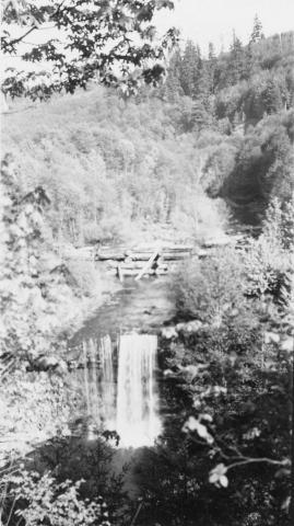 Impassable falls on Beaver Creek. The falls are about 60 feet high
Citation -
41. [Article] Middle Cow Creek Watershed assessment and action plan
The Middle Cow Creek Watershed Assessment process has been contributed to by a group of local landowners. The group met fifteen times to review data about their watershed going into the document and portions ...Citation -
42. [Article] Silver Creek Subbasin Assessment
Abstract -- The Silver Creek Subbasin Assessment was produced by the Harney County Watershed Council. The Silver Creek Subbasin is approximately 1,075,748 acres in Harney County, Oregon. The document intrudction ...Citation -
43. [Article] Ecola Creek Watershed Assessment: A Living Document
Abstract -- The report is the watershed assessment for the Ecola Creek watershed. The report contains information on channel habitat types, hydrology, water use, fisheries, aquatic and riparian habitat, ...Citation -
Abstract -- This document assesses 21 tributary sub-basins in the Bear Creek watershed in terms of history, physiography and physical structure, human demographic characteristics, channel morphology, and ...
Citation -
45. [Article] Cedar Creek 2014 Snorkel Survey
Abstract -- In July 2014 Curry Watersheds Partnership staff conducted a juvenile snorkel survey on ~3500 meters of Cedar Creek in the Euchre Creek watershed using the Rapid BioAssessment protocol.Citation -
46. [Article] Watershed response to western juniper control
Western juniper (Juniperus occidentalis) encroachment has been associated with increased soil loss and reduced infiltration resulting in the loss of native herbaceous plant communities and the bird and ...Citation -
47. [Article] Phillips Creek Watershed Assessment
Abstract -- Watershed Assessments for the Grande Ronde River Subwatersheds are being prepared for the Grande Ronde Model Watershed Program. This Watershed Assessment addresses the Phillips Creek Watershed ...Citation -
48. [Image] Spencer Creek pilot watershed analysis
"Prepared by an interagency (BLM, USFS, EPA, USFWS), interdisplinary team as part of the pilot program for revising the federal interagency guide to watershed analysis"--P. 1-3; "The Spencer Creek Watershed ...Citation -
49. [Article] Calapooya Creek Watershed Assessment and Action Plan
Abstract -- This report contains: the purpose and development of the watershed assessment, watershed description, land use, ownership, and population, past conditions from pre-settlement to current, history ...Citation -
50. [Article] Myrtle Creek Watershed Assessment and Action Plan
Abstract -- This report contains: the purpose and development of the watershed assessment, watershed description, land use, ownership, and population, past conditions from pre-settlement to current, history ...Citation