Search
You searched for:
Start Over
Olalla Creek-Lookingglass Creek Watershed
Remove constraint Olalla Creek-Lookingglass Creek Watershed
« Previous | 1 - 20 of 720 | Next »
Search Results
-
Photo was taken on the Olalla Creek-Lookingglass Creek Watershed
Citation -
97 pp. Tables, references, appendices, maps. The acreage would be divided among 17 units comprising two timber sales, to be authorized individually, and designated as Deep Six (located in Section 27, T. ...
Citation -
5 pp. The units are located in: Section 27, T. 28 S., R. 8 W., W.M.; Sections 7 and 19, T. 30 S., R. 7 W., W.M.; and Sections 1, 11, 13, and 23, T. 30 S., R. 8 W., W.M. Captured July 27, 2007.
Citation -
122 pp. Tables, figures, references, appendices, maps. Density management would be applied to approximately 665 acres of forest stands within the LSR in the Middle Fork Coquille River, East Fork Coquille ...
Citation -
The introduction provides a general description of the watershed in terms of its natural and human-made features, ownership and current land uses, and the communities within the watershed. Information ...
Citation -
64 pp. Tables, references, appendices, maps, figures. Sections 26, 27, T 29 S, R 9 W; Section 33, T 29 S, R 3 W; Section 27, T 29 S, R 3 W; Section 13, T 29 S, R 3 W; Section 22, T 30 S, R 3 W; Section ...
Citation -
7. [Article] Limiting Factors Assessment and Restoration Plan: Olalla Creek Tributary of the Yaquina Estuary
Abstract -- This document provides watershed restoration actions proposed to enhance the Coho Salmon population within the Olalla Creek subbasin in Lincoln County, Oregon. The report contains information ...Citation -
Abstract -- The assessment includes information on past conditions, current conditions of stream function, Riparian zones and wetlands, water quality/quantity, fish populations, stakeholder/landowner perspectives, ...
Citation -
9. [Article] Douglas County : Community wildfire protection plans
221 pp. Includes maps. Each of thirty identified at-risk-areas within the County received its own plan; all are included here in one file in the order in which they are listed in the Introduction, and ...Citation -
10. [Image] Opegrapha rufescens
 Spores; Location: Near Olalla Creek; Substrate: Bark, Fraxinus latifolia; Elevation: 233 meters.
Citation -
11. [Image] Opegrapha rufescens
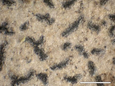 Habit; Location: Near Olalla Creek; Substrate: Bark, Fraxinus latifolia; Elevation: 233 meters.
Citation -
12. [Image] Opegrapha rufescens
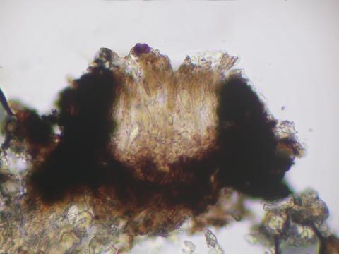 Apothecial section; Location: Near Olalla Creek; Substrate: Bark, Fraxinus latifolia; Elevation: 233 meters.
Citation -
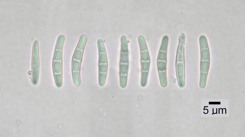
13. [Image] Opegrapha rufescens
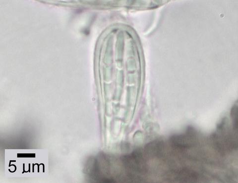 Ascus; Location: Near Olalla Creek; Substrate: Bark, Fraxinus latifolia; Elevation: 233 meters.
Citation -
14. [Article] Fanno/Tryon Creek Watershed Plan: Draft
Abstract -- The Fanno and Tryon Creeks Watershed Plan contains sections on: Introduction to the Fanno/Tryon Creek Watershed Plan, Overview-Tryon Creek Watershed, Habitat and Biological Communities-Background ...Citation -
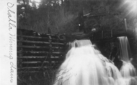
15. [Image] Olalla mining dam
-
89 pp. Tables, references, appendices, maps, illus. The proposed harvest would occur on approximately 150 acres located in Sections 9, 11, 15 and 21 of T. 29 S., R. 7 W., W.M., within the Olalla sixth-field ...
Citation -
17. [Article] Myrtle Creek Watershed assessment and action plan
The introduction provides a general description of the watershed in terms of its natural and human-made features, ownership and current land uses, and the communities within the watershed. Information ...Citation -
18. [Article] West Fork Cow Creek Watershed assessment and action plan
The introduction provides a general description of the watershed in terms of its natural and human-made features, ownership, and current land uses. Information in section 1.2 was compiled from the Oregon ...Citation -
19. [Article] Lower Cow Creek Watershed assessment and action plan
The introduction provides a general description of the watershed in terms of its natural and human-made features, ownership and current land uses, and the communities within the watershed. Information ...Citation -
Abstract -- Aquatic Inventory Project (AIP) habitat surveys for Butte Creek and Morton Creek, New River watershed.
Citation