Search
You searched for:
Start Over
Olalla Creek-Lookingglass Creek Watershed
Remove constraint Olalla Creek-Lookingglass Creek Watershed
« Previous | 31 - 40 of 720 | Next »
Search Results
-
32. [Article] Middle Rogue Watershed Assessment
Abstract -- The Middle Rogue Watershed (MRW) encompasses nearly 607 squarel miles in the northern portion of Josephine County in southern Oregon from the just below Kelsey Creek on the border of Curry ...Citation -
33. [Article] Thirtymile Creek Watershed Assessment
Abstract -- The Oregon Watershed Enhancement Board's Oregon Watershed Assessment Manual was used as the guideline for this assessment. The manual provides background information on watershed functions ...Citation -
34. [Article] Beaver Creek watershed analysis
64 pp. Tables, figures, maps, references, illus. T 12 S, R 11 W. Captured February 11, 2008.Citation -
The work upon which this report is based was supported by funds provided by the United States Department of the Interior, Office of Water Resources Research, as authorized under the Water Resources Research ...
Citation -
36. [Article] LCMP - Fish Habitat Restoration in Tenmile Creek
Abstract -- The Tenmile Watershed Restoration Study was initiated in 1991 to examine the effects of watershed restoration activities in Tenmile Creek (including the addition of large wood into the stream ...Citation -
37. [Article] Little Butte Creek Watershed Action Plan
Abstract -- This document is the Little Butte Creek Watershed Action Plan prepared for the Little Butte Creek Watershed Council and funded by the Oregon Watershed Enhancement Board. The Action Plan is ...Citation -
38. [Article] Rock and Lonerock Creeks Watershed Assessment
Abstract -- The 2011 Rock and Lonerock Creeks Watershed Assessment was produced by ABR, Inc got the Gilliam-East John Day Watershed Council and the Gilliam Soil and Water Conservation District. The purpose ...Citation -
39. [Article] Williams Creek Watershed Action Plan
Abstract -- This document is the Williams Creek Watershed Action Plan prepared for the Williams Creek Watershed Council and funded by the Oregon Watershed Enhancement Board. The Action Plan is based on ...Citation -
40. [Image] Beaver Creek falls
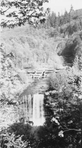 Impassable falls on Beaver Creek. The falls are about 60 feet high
Citation