Search
« Previous | 41 - 60 of 1,838 | Next »
Search Results
-
42. [Article] A physical description of the Salmon River estuary
A student report for a Civil Engineering 572 class, this document is an extensive description of the Salmon River estuary, including water flow, quality, predictions for the estuary’s future, and numerous ...Citation -
43. [Image] The main business district (the "loop"), Chicago
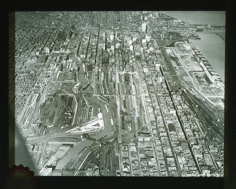 Looking north, from 20th Street to beyond Randolph Street. The Chicago Drainage Canal, its source in Lake Michigan and its north and south branches are well shown. Water flows from Lake Michigan through ...
Citation -
44. [Image] 500 ft. below great north glacier in early P.M. when water flows heavier - Cascade N. F.
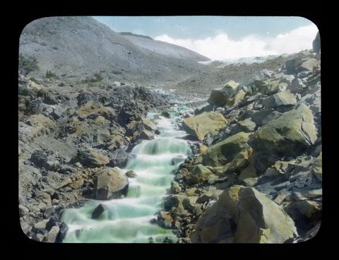 Some of the glacial streams have dry channels in the early morning but as the ice begins to melt the stream grows until by evening it is a regular torrent. The glacier can be seen in the background.
Citation -
45. [Image] Canyon near mouth of Klickitat River
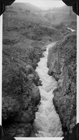 The water flow is about 782 feet per second
Citation -
Data collected from the Fern Lake watershed between 1958 and 1971 include measurements of the rate of flow of water into the lake through a single inlet stream. The objective of the work presented here ...
Citation -
47. [Article] Water Flow through Temperate Glaciers
Understanding water movement through a glacier is fundamental to several critical issues in glaciology, including glacier dynamics, glacier-induced floods, and the prediction of runoff from glacierized ...Citation -
48. [Article] Sedimentologic changes in the deposits of an evolving lahar-flood in 2006, Hood River Basin, Mount Hood, Oregon
Over a span of six days from November 2nd -- 7th, 2006 approximately 43 cm of precipitation fell over the Hood River Basin in Oregon. A lahar was initiated on the Eliot Branch of the Middle Fork Hood River ...Citation -
Experiments were carried out to study the movement of water and halide anions in perched water tables or saturated zones in the soil and upper rock mantle of eight different experimental sites located on ...
Citation -
50. [Article] Tracing Pacific water in the North Atlantic Ocean
copyrighted by American Geophysical UnionCitation -
This is a report of data and observations gathered during the Lower Deschutes Flow Study. The authors describe the area’s geography, topography, and geology. The work covers Deschutes River stream discharges ...
Citation -
52. [Article] Automated water balance procedure for large-scale experimental databases based on soil moisture
Based on the determination of the zero-flux plane, a water balance procedure for large-scale experimental databases was automated to estimate the soil water balance based on soil water content distribution ...Citation -
Copyrighted by American Geophysical Union.
Citation -
P12-201-4540NA Klamath Project, OR-CA. Plant E Outlet Transition Bridge -- Water flowing from base of the left retaining wall at Plant E. Flow was a by-product of jetting operations for Plant E west ...
Citation -
55. [Article] A new multisource and high-frequency approach to measuring δ²H and δ¹⁸O in hydrological field studies
This is the publisher’s final pdf. The published article is copyrighted by American Geophysical Union and can be found at: http://onlinelibrary.wiley.com/journal/10.1002/%28ISSN%291944-7973.Citation -
56. [Article] The development of a hydrological model of the Walla Walla Basin using Integrated Water Flow Model
The Walla Walla basin lies in an arid region of Eastern Washington and Oregon. A large portion of the area is devoted to agricultural production, relying on irrigation water diverted from the Walla Walla ...Citation -
P12-201-4441 NA Klamath Project, OR-CA. Center Canal Flume--View of outlet transition south wall after corntractor forces stopped source of water flow. Visquene was laid next to the outlet transition ...
Citation -
58. [Image] CLEAR LAKE- Ground Fracture - Southwest Shore, Section 16, T. 46 N., R. 7 E., M.D.M. - D. E.
KP-2502-R2- Klamath Project- CLEAR LAKE- Ground Fracture - Southwest Shore, Section 16, T. 46 N., R. 7 E., M.D.M. - D. E. Close-up of the water inlet to the fracture showing how the water flows to the ...Citation -
P12-201-4568NA Klamath Project, OR-CA. Ady Canal -- Siphon hydrostatic test -- Plant FF. Water in CMP was held at head of 10" using 192 GMP Homelite pump regulated by means of valve on downstream side ...
Citation -
P12-201-4438 NA Klamath Project, OR-CA. Center Canal Flume--View of flume south wall near pile cap where water exited after piping along fllume wall. This water flowed into the void adjacent to the outlet ...
Citation