Search
You searched for:
Start Over
Land use history
Remove constraint Land use history
Material Types
Image
Remove constraint Material Types: Image
« Previous | 1 - 50 of 3,178 | Next »
Search Results
-
EXECUTIVE SUMMARY This document presents the framework of a plan to reverse the decline of bull trout (Salvelinus confluentus) populations in the Klamath Basin. If successful, we expect bull trout ...
Citation -
3. [Image] Annual project history and O. & M. report of the Klamath Project, Oregon-California, 1931
Information Of Interest Source of water supply: Upper Klamath Lake, Lost River and Clear Lake. Area of drainage basin: 3,700 square miles. Length of irrigation season: From April 15 to September ...Citation -
Some issues include, photographs, maps, and tables for land acquired, hydrographies, contracts, etc.; Description based on Annual rept. of the Klamath project: Oregon and California for calendar year 1913. ...
Citation -
5. [Image] Klamath Project annual history, 1949
Ill., maps (some color), photographs; Includes fiscal year financials, photographs, maps, crop and livestock yields, irrigation and drainage and irrigation pumping plant operations, WPA camp maintenance, ...Citation -
6. [Image] Annual project history and O. & M. report of the Klamath Project, Oregon-California, 1932
Ill., maps (some color), photographs; Includes fiscal year financials and contracts, land acquired, land leased, project organization chart, litigations, photographs, maps, hydrographs, etc.; Includes ...Citation -
7. [Image] Annual project history and O. & M. report of the Klamath Project, Oregon-California, 1935
Ill., maps (some color), photographs; Includes fiscal year financials and contracts, land acquired, land leased, project organization chart, litigations, photographs, maps, hydrographs, etc.; Includes ...Citation -
8. [Image] Annual project history and O. & M. report of the Klamath Project, Oregon-California, 1941
Ill., maps (some color), photographs; Includes fiscal year financials and contracts, land acquired, land leased, project organization chart, litigations, photographs, maps, hydrographs, etc.; Includes ...Citation -
Ill., maps (some color), photographs; Includes financial documents, organization chart, photographs, maps, water quality reports, and agricultural economics; Includes index; Title covers: calendar years ...
Citation -
10. [Image] Reclaiming Tule Lake land
KP-1113-R2; Looking out across NW1/4. Section 2, T.46 N., R.4 E. Area near pumps used in draining the land; April 17, 1945; Photo by R. S. HopkinsCitation -
11. [Image] Annual project history and O. & M. report of the Klamath Project, Oregon-California, 1926
Ill., maps (some color), photographs; Includes fiscal year financials and contracts, land acquired, land leased, project organization chart, litigations, photographs, maps, hydrographs, etc.; Includes ...Citation -
12. [Image] Annual project history and O. & M. report of the Klamath Project, Oregon-California, 1918
Ill., maps (some color), photographs; Includes fiscal year financials and contracts, land acquired, land leased, project organization chart, litigations, photographs, maps, hydrographs, etc.; Includes ...Citation -
13. [Image] Annual project history and O. & M. report of the Klamath Project, Oregon-California, 1919
Ill., maps (some color), photographs; Includes fiscal year financials and contracts, land acquired, land leased, project organization chart, litigations, photographs, maps, hydrographs, etc.; Includes ...Citation -
14. [Image] Annual project history and O. & M. report of the Klamath Project, Oregon-California, 1921
Ill., maps (some color), photographs; Includes fiscal year financials and contracts, land acquired, land leased, project organization chart, litigations, photographs, maps, hydrographs, etc.; Includes ...Citation -
15. [Image] Annual project history and O. & M. report of the Klamath Project, Oregon-California, 1927
Ill., maps (some color), photographs; Includes fiscal year financials and contracts, land acquired, land leased, project organization chart, litigations, photographs, maps, hydrographs, etc.; Includes ...Citation -
16. [Image] Annual project history and O. & M. report of the Klamath Project, Oregon-California, 1928
Ill., maps (some color), photographs; Includes fiscal year financials and contracts, land acquired, land leased, project organization chart, litigations, photographs, maps, hydrographs, etc.; Includes ...Citation -
17. [Image] Annual project history and O. & M. report of the Klamath Project, Oregon-California, 1929
Ill., maps (some color), photographs; Includes fiscal year financials and contracts, land acquired, land leased, project organization chart, litigations, photographs, maps, hydrographs, etc.; Includes ...Citation -
18. [Image] Annual project history and O. & M. report of the Klamath Project, Oregon-California, 1930
Ill., maps (some color), photographs; Includes fiscal year financials and contracts, land acquired, land leased, project organization chart, litigations, photographs, maps, hydrographs, etc.; Includes ...Citation -
19. [Image] Annual project history and O. & M. report of the Klamath Project, Oregon-California, 1934
Ill., maps (some color), photographs; Includes fiscal year financials and contracts, land acquired, land leased, project organization chart, litigations, photographs, maps, hydrographs, etc.; Includes ...Citation -
20. [Image] Annual project history and O. & M. report of the Klamath Project, Oregon-California, 1936
Ill., maps (some color), photographs; Includes fiscal year financials and contracts, land acquired, land leased, project organization chart, litigations, photographs, maps, hydrographs, etc.; Includes ...Citation -
21. [Image] Annual project history and O. & M. report of the Klamath Project, Oregon-California, 1937
Ill., maps (some color), photographs; Includes fiscal year financials and contracts, land acquired, land leased, project organization chart, litigations, photographs, maps, hydrographs, etc.; Includes ...Citation -
22. [Image] Annual project history and O. & M. report of the Klamath Project, Oregon-California, 1938
Ill., maps (some color), photographs; Includes fiscal year financials and contracts, land acquired, land leased, project organization chart, litigations, photographs, maps, hydrographs, etc.; Includes ...Citation -
23. [Image] Annual project history and O. & M. report of the Klamath Project, Oregon-California, 1939
Ill., maps (some color), photographs; Includes fiscal year financials and contracts, land acquired, land leased, project organization chart, litigations, photographs, maps, hydrographs, etc.; Includes ...Citation -
24. [Image] Annual project history and O. & M. report of the Klamath Project, Oregon-California, 1940
Ill., maps (some color), photographs; Includes fiscal year financials and contracts, land acquired, land leased, project organization chart, litigations, photographs, maps, hydrographs, etc.; Includes ...Citation -
25. [Image] Annual project history and O. & M. report of the Klamath Project, Oregon-California, 1942
Ill., maps (some color), photographs; Includes fiscal year financials and contracts, land acquired, land leased, project organization chart, litigations, photographs, maps, hydrographs, etc.; Includes ...Citation -
26. [Image] Annual project history and O. & M. report of the Klamath Project, Oregon-California, 1943
Ill., maps (some color), photographs; Includes fiscal year financials and contracts, land acquired, land leased, project organization chart, litigations, photographs, maps, hydrographs, etc.; Includes ...Citation -
27. [Image] F. H. Carter, member of the Carter Land Co.
Also a member of the Board of Regents for many years.Citation -
Ill., maps (some color), photographs; Includes fiscal year financials, maps, photographs, agricultural economics and crop yield, some grazing financial information with cost of water usage, tables for ...
Citation -
Klamath Project (United States); Water use -- Klamath River Watershed (Oregon and California); Water resources development -- Klamath River Watershed (Oregon and California); Irrigation --Klamath River ...
Citation -
30. [Image] Klamath Project annual history, 1950
Ill., maps (some color), photographs; Includes fiscal year financials, photographs, maps, crop and livestock yields, irrigation and drainage and irrigation pumping plant operations, WPA camp maintenance, ...Citation -
Ill., maps (some color), photographs; Includes organization of Klamath District with official correspondence and description of the Klamath project, an organization chart, fiscal year financials, photographs, ...
Citation -
Title covers: May 1, 1903 to December 31, 1912 in a single issue; Dates of the beginning year(s) of publication are derived from the 1903 to December 31, 1912, History of the Klamath Project and from ...
Citation -
The history of geothermal exploration in Hawaii is reviewed briefly. The nature and occurrences of geothermal resources are presented island by island. An overview of geothermal markets is presented. Other ...
Citation -
34. [Image] Klamath Project annual history, 1951
Ill., maps (some color), photographs; Includes fiscal year financials, photographs, maps, crop and livestock yields, irrigation and drainage and irrigation pumping plant operations, WPA camp maintenance, ...Citation -
Ill., maps (some color), photographs; Includes fiscal year financials, maps, photographs, agricultural economics and crop yield, some grazing financial information with cost of water usage, tables for ...
Citation -
INTRODUCTION AND GENERAL General Description of the Project Location. The Klamath Project is in the Upper Klamath River Basin, east of the Cascade Range. It is located in Klamath County, Oregon, and ...
Citation -
Ill., maps (some color), photographs; Includes fiscal year financials, maps, photographs, agricultural economics and crop yield, some grazing financial information with cost of water usage, tables for ...
Citation -
Ill., maps (some color), photographs; Includes organization of Klamath District with official correspondence and description of the Klamath project, an organization chart, fiscal year financials, photographs, ...
Citation -
Some issues include, photographs, maps, and tables for land acquired, hydrographies, contracts, etc.; Description based on Annual report of the Klamath project: Oregon and California for calendar year ...
Citation -
Ill., maps (some color), photographs; Includes organization of Klamath District with official correspondence and description of the Klamath project, an organization chart, fiscal year financials, photographs, ...
Citation -
41. [Image] Region II Klamath Project annual history, 1945
Ill., maps (some color), photographs; Includes fiscal year financials, photographs, crop and livestock yields, water storage and distribution, hydrography report, etc.; Title covers: calendar years for ...Citation -
42. [Image] Nevada Fact Book and Energy Reference
The purpose of this working document is to serve Nevada Operations Office management authorities and other DOE officials as a quick and convenient general reference. It also may be useful as a starting ...Citation -
43. [Image] On Grants City Point Railroad
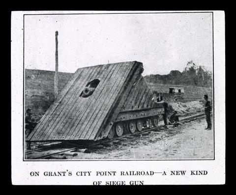 The Federals were not the first to use a gun mounted on the railway trucks. In the defense of Richmond during the Seven Days' and at the attack on Savage's Station the Confederates had mounted a field ...
Citation -
44. [Image] Klamath Project annual history, 1952
Klamath Project (United States); Water use -- Klamath River Watershed (Oregon and California); Water resources development -- Klamath River Watershed (Oregon and California); Irrigation --Klamath River ...Citation -
INTRODUCTION AND GENERAL Genex*al Description of the Project Location. The Klamath Project is in the Upper Klamath River Basin, east of the Cascade Range. It is located in Klamath Comity, Oregon, ...
Citation -
"BLM/OR/WA/PL-02/038+1792"--P. [2] of cover; Cover title; Includes bibliographical references (v. 2, p. 219-228) and index
Citation -
Humans have altered the Klamath River Canyon in many ways. This study focuses on the years from 1955 to 2003. One substantial alteration is the conversion of terraces into irrigated pastures for agriculture ...
Citation -
48. [Image] The doctrine of prior appropriation : effects upon water rights in the Upper Klamath Basin
Undergraduate student project, Geomatics 466, Boundary Law IICitation -
49. [Image] A Bucyrus-Erie dragline dumping soil in Tulelake
KP-1194-R2 - Klamath Project. Region II. Another yard and a half of soil in Tulelake is dumped from a Bucyrus Erie dragline that is being used to construct a new drain to take care of the expanding agricultural ...Citation -
P12-201-4309 NA Klamath Project, OR-CA. Break in earth dike holding farm land flood water. Dike located on west side of KSD. Approx. 8 man hours and 2 hrs. of Case 580 time was used; January 17, 1977; ...
Citation