Search
You searched for:
Start Over
Hudson's Bay Company
Remove constraint Hudson's Bay Company
Material Types
Image
Remove constraint Material Types: Image
« Previous | 1 - 50 of 81 | Next »
Search Results
-
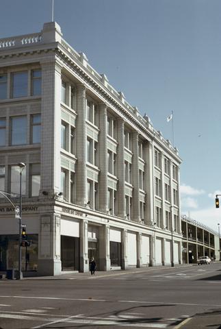 This image is included in Building Oregon: Architecture of Oregon and the Pacific Northwest, a digital collection which provides documentation about the architectural heritage of the Pacific Northwest....
Citation -
2. [Image] Fort Hall, Idaho
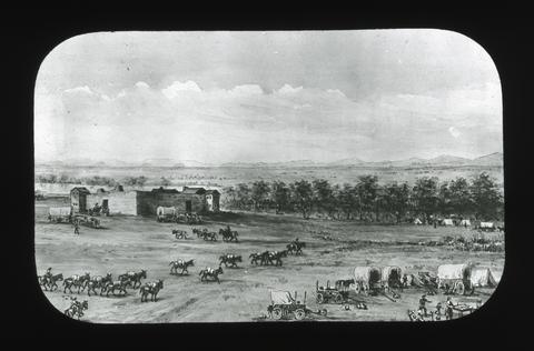 Fort Hall, built by N.J. Wyeth in 1834, for a furtrading post, was sold to the Hudson Bay Company in 1837 and retained by it until the treaty of 1846. Trails to California branched off here, and attempts ...
Citation -
3. [Image] Type of gun traded to the Indians for furs
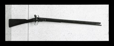 This picture shows the kind of gun which was bartered by the Hudson Bay Company to the Indians for furs.
Citation -
4. [Image] John McLoughlin
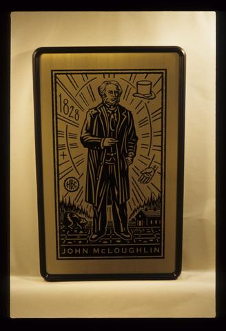 John McLoughlin is one is a series of seventeen bronze medallions that depict icons of the state of Oregon. The 1957 Legislature bestowed upon Dr. John McLoughlin the honorary title of "Father of Oregon" ...
Citation -
6. [Image] Monument to Hudson
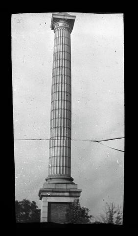 On a high point of land in the northern part of the City, overlooking the Hudson River there stands a beautiful monument erected to the memory of Henry Hudson. It is a marble column in the Doric pattern, ...
Citation -
"Submitted to Klamath Falls Resource Area, Bureau of Land Management, Lakeview District, Klamath Falls, Oregon." ; "Contract no.: HAP032021."; Includes bibliographical references (p. 178-200)
Citation -
8. [Image] Resolving the Klamath
"October 1999"; Cover titleCitation -
9. [Image] Lakeview proposed resource management plan and final environmental impact statement [volume 1]
4 v.; maps (some col.); "August 2002"; "January 2003" -- coverCitation -
10. [Image] The Klamath Project
"Seventh draft"; Includes bibliographical references and indexCitation -
Foreword The Soil Survey of Klamath County, Oregon, Southern Part, is the product of many soil scientists, plant specialists, soil engineers, extension specialists, land owners, and others who worked ...
Citation -
The Oregon Plan for Salmon and Watersheds Biennial Report 2005-2007. This is the sixth report on the Oregon Plan for Salmon and Watersheds. The report provides an update on the accomplishments and continuing ...
Citation -
13. [Image] Dr. John McLoughlin
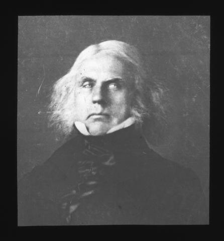 In 1824 Dr. John Mc Loughlin became Chief Factor for the Hudson Bay Co. in the Columbia river region. He was a man of kindly disposition but resolute character and was a genius in leadership. He commanded ...
Citation -
14. [Image] Home of Doctor John McLoughlin at Oregon City
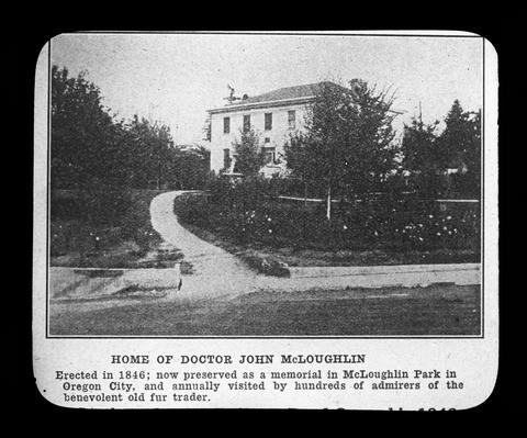 Dr. McLoughlin, while connected with the Hudson Bay Co, had selected a place near Willamette Falls as the natural location for a future city. When he severed his relationship with that company he established ...
Citation -
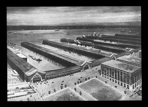
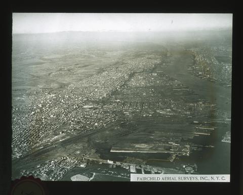 The Hudson River and part of Manhattan Island are seen on the right. Railroad terminals and docks in the foreground. Hackensack Meadows (a former bay, now filled with silt, up to the level of high tide). ...
Citation -
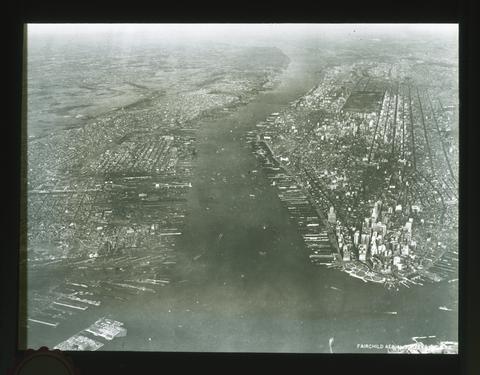 Looking north, the docks, and Wall Street district are prominent. The fact that the earth's surface in the northeastern United States has lately subsided beneath sea-level accounts for New York City's ...
Citation -
17. [Image] Mrs. Dye's home on the height, Oregon City
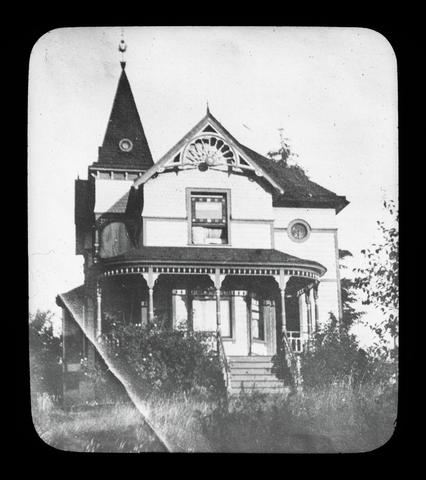 Mrs. Dye's home is on the Heights, Oregon City, overlooking the Willamette River. "Not only pioneers but voyagers of the Hudson Bay era, Indians and Missionaries have made pilgrimages to this home and ...
Citation -
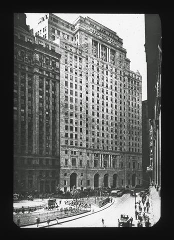
18. [Image] Skyscrapers of New York
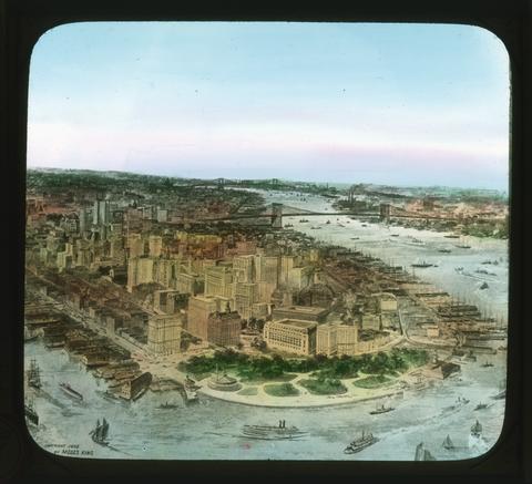 This picture shows the lower end of Manhattan Island. This is the business and financial center of New York city, and the office buildings are commonly known as skyscrapers because they are so high. The ...
Citation -
19. [Image] Fort Vancouver in 1845
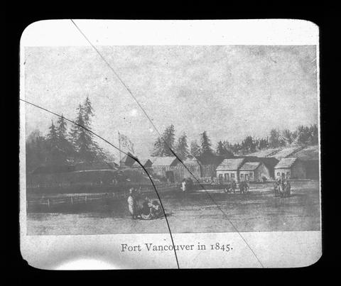 In 1824 Dr. John McLoughlin built the first Fort Vancouver on a broad high prairie nearly a mile back from the river. It had no block houses, which is evidence of the amicable relations between Dr. McLoughlin ...
Citation -
20. [Image] OIMB slide 4646
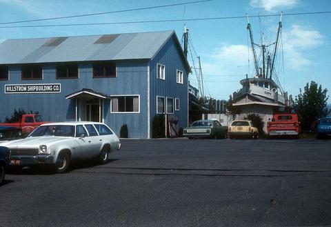 shipbuilding company building and ships
Citation -
21. [Image] OIMB slide 4671
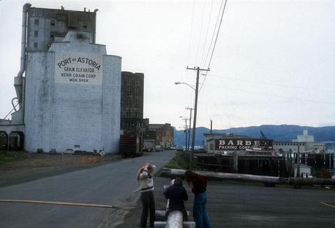 packing company
Citation -
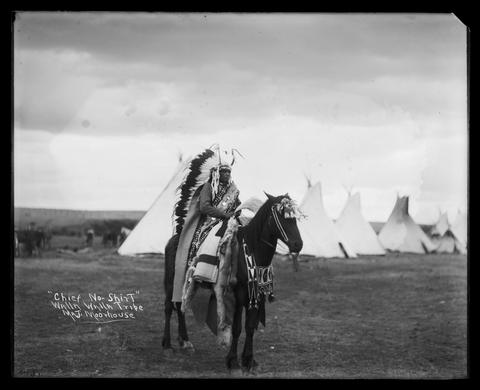 A Native American man, identified as Chief No-Shirt of the Walla Walla Tribe, is sitting on a horse in a grass field. An encampment, consisting of tipis, wagons, and horses, appears in the background. ...
Citation -
23. [Image] Alexander Mackenzie
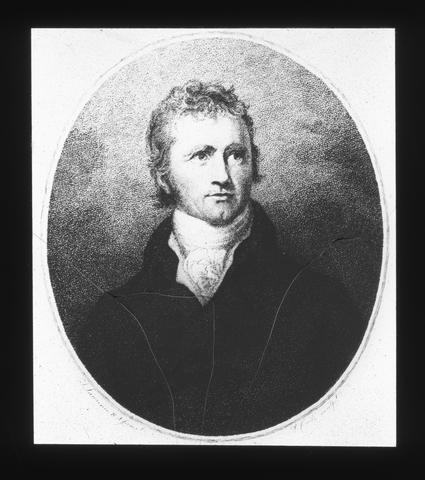 In 1789 Mackenzie, who was a printer in the Northwest Fur Co., explored westward from Hudson's Bay beyond the Great Slave Lake and discovered the river which now bears his name. He was convinced that an ...
Citation -
25. [Image] Egyptian Theatre (Coos Bay, Oregon)
 This image is included in Building Oregon: Architecture of Oregon and the Pacific Northwest, a digital collection which provides documentation about the architectural heritage of the Pacific Northwest.; ...
Citation -
26. [Image] Francis Lincoln, Cayuse Tribe; PH036_4688
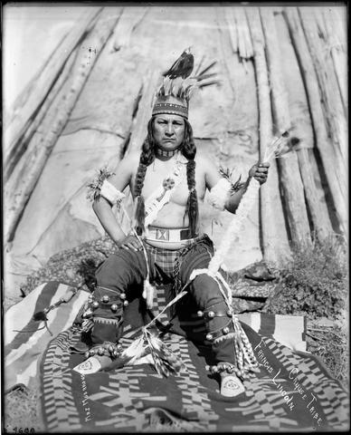 A Native American man, identified as Francis Lincoln of the Cayuse Tribe, is sitting in front of a tipi, dressed in full regalia. He is wearing a headdress with feathers, cloth pants made from a blanket, ...
Citation -
27. [Image] On the upper Amazon
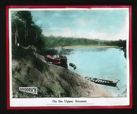 The Amazon River is the largest in the world; it is not the longest for the Missouri-Mississippi River is longer, but it contains more water than any other river in the world. The amount of fresh water ...
Citation -
28. [Image] Native boat, Kongo River
 The Kongo, while not so long as the Nile, is greater in volume than any other river in Africa, is greater in volume than the Mississippi, and is second only to the Amazon. It drains a basin as large as ...
Citation -
29. [Image] Lumber storage at Owen-Oregon Lumber Company
Interior of lumber storage building with lumber stacked at varying levels in bays to right, man working with large boards on carts in foreground; Carts run on tracks laid into floorCitation -
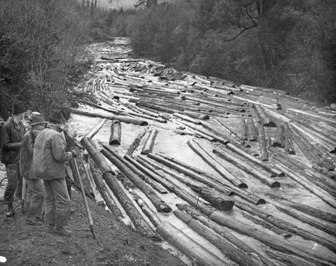 This was one of the last log drives in the U.S.
Citation -
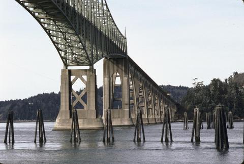
33. [Image] Conde B. McCullough Memorial Bridge (North Bend, Oregon); Coos Bay Bridge (North Bend, Oregon)
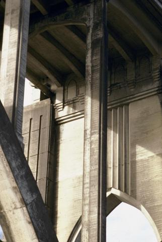 This image is included in Building Oregon: Architecture of Oregon and the Pacific Northwest, a digital collection which provides documentation about the architectural heritage of the Pacific Northwest....
Citation -
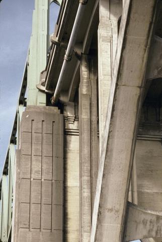
34. [Image] Conde B. McCullough Memorial Bridge (North Bend, Oregon); Coos Bay Bridge (North Bend, Oregon)
 This image is included in Building Oregon: Architecture of Oregon and the Pacific Northwest, a digital collection which provides documentation about the architectural heritage of the Pacific Northwest....
Citation -
35. [Image] Conde B. McCullough Memorial Bridge (North Bend, Oregon); Coos Bay Bridge (North Bend, Oregon)
 This image is included in Building Oregon: Architecture of Oregon and the Pacific Northwest, a digital collection which provides documentation about the architectural heritage of the Pacific Northwest....
Citation -
36. [Image] Conde B. McCullough Memorial Bridge (North Bend, Oregon); Coos Bay Bridge (North Bend, Oregon)
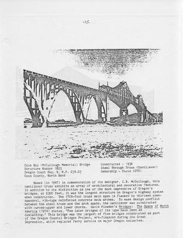 This image is included in Building Oregon: Architecture of Oregon and the Pacific Northwest, a digital collection which provides documentation about the architectural heritage of the Pacific Northwest....
Citation -
37. [Image] Glimpse of Lake Manapouri
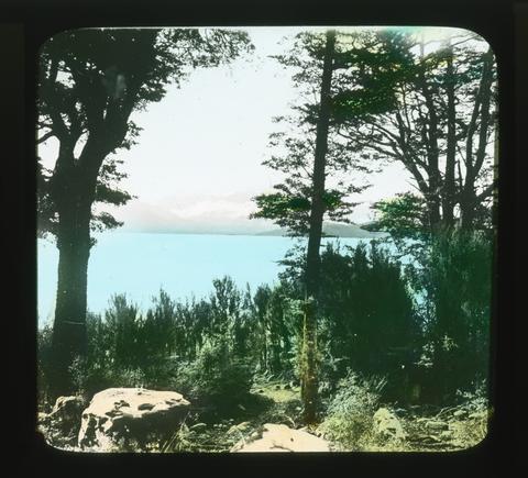 Image Description from historic lecture booklet: "Almost entirely surrounded by mountains, studded with countless wooded islands, and indented with lovely little bays, Manapouri, or perhaps more correctly ...
Citation -
38. [Image] Jennie Peo, with children, in camp; PH036_4081
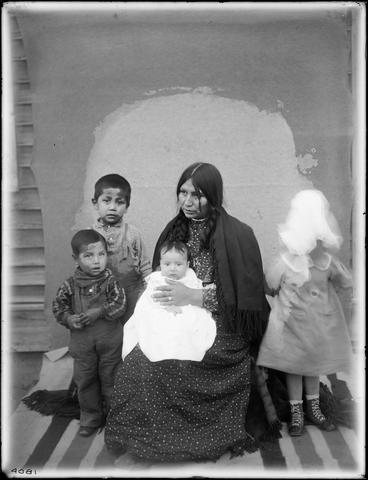 This photograph was identified as 'Jennie Peo, with children, in camp' from Major Moorhouse. From a unidentified tribal member it is 'Mose and Levi' for the two boys and 'Jenny and Eva Van Pelt' both with ...
Citation -
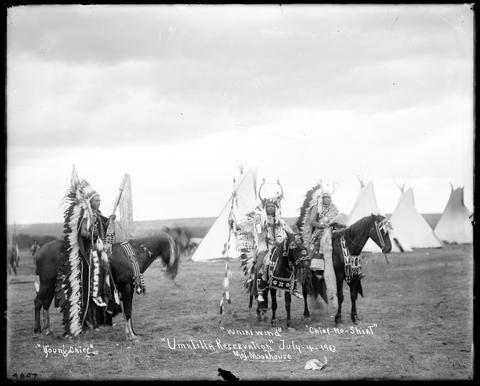 Three Native American men, identified as Young Chief, Whirlwind, and Chief No-shirt, are mounted on dark-colored horses on a plain in front of four tipis. Each man carries a staff with ermine, eagle feathers, ...
Citation -
40. [Image] Bowling green
 Fort Amsterdam was erected on the site of the present Custom House facing Bowling Green. At this time the island ended there. The extreme lower edge, occupied now by streets to South Ferry and the Battery ...
Citation -
Annual; Description based on: 1938 issue; Cover title
Citation -
Abstract The objectives of this two-year study (1998-1999) were to document distribution, abundance, age class structure, recruitment success, and habitat use by all life history stages of shortnose and ...
Citation -
43. [Image] EPA 314 clean lakes program: phase I diagnostic/feasibility project: Upper Klamath Lake, Oregon
SUMMARY PROBLEM DEFINITION Upper Klamath Lake, a 90,000 acre body of water located in south-central Oregon, is eutrophic and has reached a stage where summer algal and macrophyte productivity causes ...Citation -
Ill., maps (some color), photographs; Includes organization of Klamath District with official correspondence and description of the Klamath project, an organization chart, fiscal year financials, photographs, ...
Citation -
Following is a digital file of the Report of Lieut. Henry L. Abbot, Corps of Topographical Engineers upon Explorations for a Railroad Route from the Sacramento Valley to the Columbia River, made by Lieut. ...
Citation -
CONTENTS PAGE I. THE SALMON AND THE FISHERY OF KLAMATH RIVER 2695 Introduction 2697 General Characteristics of Klamath River Salmon 2699 Species Other Than King Salmon 26916 The Spring Migration (Immigration) ...
Citation -
47. [Image] Settler's guide
This brochure was probably published by the United States Bureau of Reclamation. It was compiled to provide information on the requirements and recommendations regarding homesteading on Tule Lake.Citation -
Includes Klamath River Basin; Chiefly tables; Includes indexes; Prepared in cooperation with the states and other agencies
Citation -
Ill., maps (some color), photographs; Includes organization of Klamath District with official correspondence and description of the Klamath project, an organization chart, fiscal year financials, photographs, ...
Citation