Search
You searched for:
Start Over
Watersheds
Remove constraint Watersheds
Material Types
Image
Remove constraint Material Types: Image
« Previous | 1 - 100 of 904 | Next »
Search Results
-
"February 1998."
Citation -
3. [Image] Spencer Creek pilot watershed analysis
"Prepared by an interagency (BLM, USFS, EPA, USFWS), interdisplinary team as part of the pilot program for revising the federal interagency guide to watershed analysis"--P. 1-3; "The Spencer Creek Watershed ...Citation -
 Special scientific report ; no 51
Citation -
"January 2001."
Citation -
Draft; Title from title screen (viewed on Mar. 17, 2006); "October 2005."; "EPA 841-B-05-005."; Includes bibliographical references
Citation -
8. [Image] GERBER WATERSHED
KP-2538-R2-Klamath Project - GERBER WATERSHED. View east northeast from Yainax Butte. Upper end of Dry Prairie watershed shows in the lower right portion of the photo; November 25, 1959; Photo by R.G. ...Citation -
9. [Image] CLEAR LAKE WATERSHED
KP-2327-R2 - Klamath Project--CLEAR LAKE WATERSHED Snow cover on upper levels of relatively flat watershed during snow melting period; March 23, 1956; Photo by C. D. LawrenceCitation -
10. [Image] CLEAR LAKE WATERSHED
KP-2328-R2 - Klamath Project--CLEAR LAKE WATERSHED. Lower part of watershed southeast of Clear Lake. Note numerous ponded areas; March 23, 1956; Photo by C. D. LawrenceCitation -
11. [Image] CLEAR LAKE WATERSHED
KP-2329-R2 - Klamath Project--CLEAR LAKE WATERSHED. Intermediate level on watershed during snowmelt period. Note numerous depressions tending to hold and regulate runoff; March 23, 1956; Photo by C. D. ...Citation -
12. [Image] Upper Big Redfish Lake, Idaho
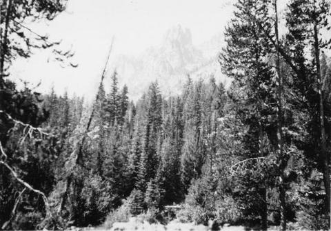 Showing character of watershed at the Upper Big Redfish Lake, Idaho
Citation -
The paper discusses the changes in the hydrology and water use in the Klamath River Watershed and the Lower Klamath Lake prior to and after the Klamath Reclamation Project. Vegetation and soil conditions ...
Citation -
14. [Image] Deschutes River Watershed south of Bend
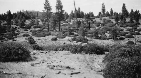 Typical watershed covering for some distance south of Bend. Rounded clumps are mainly green-leaf manzanita with some Ceanothus and Ribes
Citation -
15. [Image] View of watershed at Hot Springs
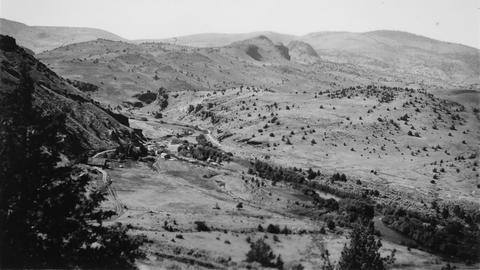 Warm Springs River and watershed area
Citation -
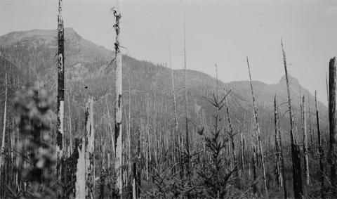
16. [Image] Upper Cispus River watershed
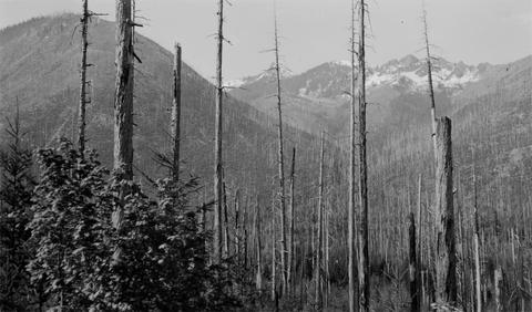 Watershed of Upper Cispus River showing extensive burn-over area
Citation -
Only portions of issues of The Water Report are available in the Klamath Waters Digital Library. See the full report at http://www.thewaterreport.com/
Citation -
KP-2492- Klamath Project - CLEAR LAKE WATERSHED. Water held behind dam which is located in the upper right-hand corner of the photo; April 9, 1959; Photo by R.G. Pollan
Citation -
KP-2493-R2- Klamath Project - CLEAR LAKE WATERSHED. Spillway at right; April 9, 1959; Photo by R.G. Pollan
Citation -
KP-2494-R2- Klamath Project - CLEAR LAKE WATERSHED. Note water area in distance; April 9, 1959; Photo by R.G. Pollen
Citation -
KP-2495-R2- Klamath Project - CLEAR LAKE WATERSHED. Spillway section in right foreground; April 9, 1959; Photo by R.G. Pollen
Citation -
22. [Image] CLEAR LAKE WATERSHED
KP-2531-R2-Klamath Project -- CLEAR LAKE WATERSHED. View looking north along dam at "Reservoir F"; November 24, 1959; Photo by R.G. PollanCitation -
23. [Image] CLEAR LAKE WATERSHED
KP-2532-R2-Klamath Project -- CLEAR LAKE WATERSHED. View looking south from point of confluence of two sidhill drains at extreme north end of valley. Principal feature is recently excavated drain extending ...Citation -
24. [Image] CLEAR LAKE WATERSHED
KP-2533-R2-Klamath Project -- CLEAR LAKE WATERSHED. View toward southwest along Avanzino Reservoir Dam showing one outlet gate. A second gate, partially submerged, is at the distant end of the dam; November ...Citation -
25. [Image] CLEAR LAKE WATERSHED
KP-2534-R2-Klamath Project -- CLEAR LAKE WATERSHED. View north showing Janes Reservoir Dam. The new embankment on top of the dam was added during 1959; November 24, 1959; Photo by R.G. PollanCitation -
26. [Image] CLEAR LAKE WATERSHED
KP-2535-R2-Klamath Project - CLEAR LAKE WATERSHED. Recently constructed outlet through Janes Reservoir Dam. View looking north; November 24, 1959; Photo by R.G. PollanCitation -
27. [Image] GERBER WATERSHED
KP-2536-R2-Klamath Project - GERBER WATERSHED. View southeast from Yainax Butte. Dry Prairie is in the foreground; beyond, in the distant background, Gerber Reservoir can be seen; November 25, 1959; Photo ...Citation -
28. [Image] GERBER WATERSHED
KP-2537-R2-Klamath Project - GERBER WATERSHED. View south southeast from Yainax Butte. Dry Prairie is in the foreground. Horsefly Mountain is in the middle of the picture; November 25, 1959; Photo by R...Citation -
29. [Image] CLEAR LAKE WATERSHED - Butcher Swamp
KP-2449-R2 - Klamath Project - CLEAR LAKE WATERSHED. Butcher Swamp. Dike in center of picture. View looking north; February 21, 1958; Photo by K. J. GreeneCitation -
30. [Image] CLEAR LAKE WATERSHED
KP-2450-R2 - Klamath Project - CLEAR LAKE WATERSHED. Boles Meadow from northwest showing dike at entrance to channel and possible dam site in Boles Creek in foreground; February 21, 1958; Photo by K. ...Citation -
KP-2452-R2 - Klamath Project - CLEAR CREEK WATERSHED; February 21, 1958; Photo by K. J. Greene
Citation -
KP-2453-R2 - Klamath Project - CLEAR LAKE WATERSHED. Note dikes and canals; February 21, 1958; Photo by K. J. Greene
Citation -
Report (to accompany S. 2882)
Citation -
34. [Image] ROUND VALLEY RESERVOIR, GERBER WATERSHED
KP-2607-R2-Klamath Project - ROUND VALLEY RESERVOIR, GERBER WATERSHED. View looking east along upstream face of dam, showing outlet works; June 23, 1961; Photo by L. McAnultyCitation -
35. [Image] LITTLE SQUAW FLAT RESERVOIR, GERBER WATERSHED
KP-2608-R2-Klamath Project - LITTLE SQUAW FLAT RESERVOIR, GERBER WATERSHED. View looking north from dam, showing area under water; June 23, 1961; Photo by L. McAnultyCitation -
36. [Image] DRY PRAIRIE RESERVOIR, GERBER WATERSHED
KP-2609-R2-Klamath Project -- DRY PRAIRIE RESERVOIR, GERBER WATERSHED. View looking west along dam, showing spillway and water area behind dam; June 23, 1961; Photo by L. McAnultyCitation -
37. [Image] DRY PRAIRIE RESERVOIR, GERBER WATERSHED
KP-2610-R2-Klamath Project -- DRY PRAIRIE RESERVOIR, GERBER WATERSHED. View looking east along dam, showing small portion of water impounded behind dam; June 23, 1961; Photo by L. McAnultyCitation -
38. [Image] ROUND VALLEY RESERVOIR, GERBER WATERSHED
KP-2611-R2-Klamath Project -- ROUND VALLEY RESERVOIR, GERBER WATERSHED. View looking southwest from outlet structure, showing reservoir area and water impounded behind dam. (Reservoir nearly empty); June ...Citation -
39. [Image] ARKANSAS FLAT RESERVOIR, GERBER WATERSHED
KP-2613-R2-Klamath Project -- ARKANSAS FLAT RESERVOIR, GERBER WATERSHED. View looking south; July 7, 1961; Photo by K.J. GreeneCitation -
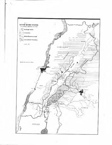
40. [Image] STRAWBERRY RESERVOIR, GERBER WATERSHED
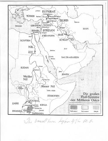
KP-2614-R2-Klamath Project -- STRAWBERRY RESERVOIR, GERBER WATERSHED. Aerial view looking north. Storage at low stage; July 7, 1961; Photo by K.J. GreeneCitation -
41. [Image] MALLORY RESERVOIR, GERBER WATERSHED
KP-2615-R2-Klamath Project -- MALLORY RESERVOIR, GERBER WATERSHED. Aerial view of empty reservoir, looking northwest; July 7, 1961; Photo by K.J. GreeneCitation -
42. [Image] KENO RESERVOIR, GERBER WATERSHED
KP-2616-R2-Klamath Project -- KENO RESERVOIR, GERBER WATERSHED. View looking north; July 7, 1961; Photo by K.J. GreeneCitation -
43. [Image] Watershed Initiatives
-
44. [Image] Watershed Initiatives
-
45. [Image] Watershed Initiatives
-
46. [Image] Watershed Initiatives
-
47. [Image] Pulp Ponds
 A cibachrome print of a landscape photograph featuring black shapes bordered by white. The focus is American river watersheds.
Citation -
48. [Image] Gyalectaria diluta
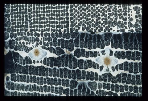
 Apothecial section POL; Habitat: Old Douglas fir forest; Location: W slope Cascades, H. J. Andrews Exptl. For., S of Watershed 10; Substrate: Branch, tree; Elevation: 610 meters; Notes: Original ID as ...
Citation -
49. [Image] Gyalectaria diluta
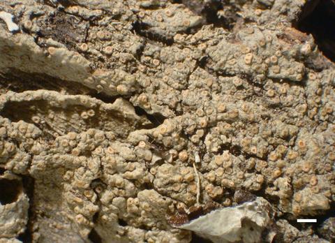 Habit; Habitat: Old Douglas fir forest; Location: W slope Cascades, H. J. Andrews Exptl. For., S of Watershed 10; Substrate: Branch, tree; Elevation: 610 meters; Notes: Original ID as Ochrolechia. On limbs ...
Citation -
50. [Image] Gyalectaria diluta
 Apothecial section; Habitat: Old Douglas fir forest; Location: W slope Cascades, H. J. Andrews Exptl. For., S of Watershed 10; Substrate: Branch, tree; Elevation: 610 meters; Notes: Original ID as Ochrolechia. ...
Citation -
51. [Image] Gyalectaria diluta
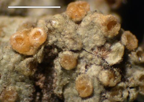 Apothecia; Habitat: Old Douglas fir forest; Location: W slope Cascades, H. J. Andrews Exptl. For., S of Watershed 10; Substrate: Branch, tree; Elevation: 610 meters; Notes: Original ID as Ochrolechia. ...
Citation -
52. [Image] Watershed of Upper Cispus River
 Watershed of Upper Cispus River showing extensive burn-over area and mountainous terrain
Citation -
53. [Image] Watershed between Loon and Cougar Creeks
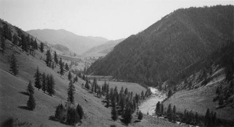 Typical watershed between Loon and Cougar Creeks. Broad benches are common
Citation -
54. [Image] Gerber-Willow Valley Watershed Analysis
x, 386 p., ill., maps (some col.); Cover title; "July 2003"Citation -
"Prepared for Klamath Basin Ecosystem Foundation, and the Upper Williamson River Catchment Group, in cooperation with the Upper Klamath Basin Working Group, and the Klamath Watershed Council."
Citation -
Cover title; "April 2001."; Includes bibliographical references
Citation -
Abstract The Secretaries of Agriculture and the Interior propose limited changes to language about how to demonstrate that projects follow the Aquatic Conservation Strategy, part of the Northwest Forest ...
Citation -
KP-1725 - Klamath Project. Portions of the Gerber Reservoir watershed on the Klamath Project comparable to this show little evidence of erosion. Localized instances of gullying have been observed in scattered ...
Citation -
59. [Image] Fire has devastated a considerable number of areas such as this on the Williamson River watershed
KP-1726 - Klamath Project. Despite this lack of cover, erosion damage has not reached aggravated proportions resulting in damage to Upper Klamath Lake; June 18, 1948; Photo by A. J. BurrowsCitation -
60. [Image] Klamath River Basin hydrologic conditions prior to the September 2002 die-off of salmon and steelhead
Includes bibliographical references (p. 10)Citation -
"Open file report SW 04-001"
Citation -
Some issues include, photographs, maps, and tables for land acquired, hydrographies, contracts, etc.; Description based on Annual rept. of the Klamath project: Oregon and California for calendar year 1913. ...
Citation -
63. [Image] Report of the Oregon Klamath River Commission on water resources and requirements of the Upper Klamath basin
The Oregon Klamath River Commission was given the specific assignment of cooperating with the California Klamath River Commission in formulating and submitting to the legislative assemblies of both state ...Citation -
"This report describes results of a reconnaissance level field investigation of the quality of irrigation drain water and the effects of its use on federally managed wildlife refuges in the Klamath Basin, ...
Citation -
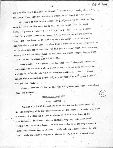
66. [Image] General Physiography - Nile System
-
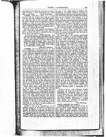
67. [Image] Bibliography
-
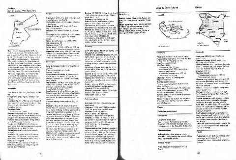
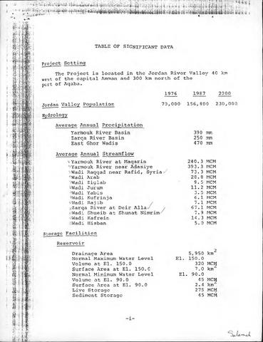
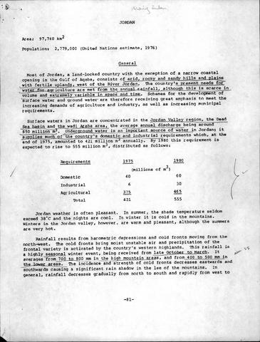
71. [Image] Ch. 1: Project setting and tables
-
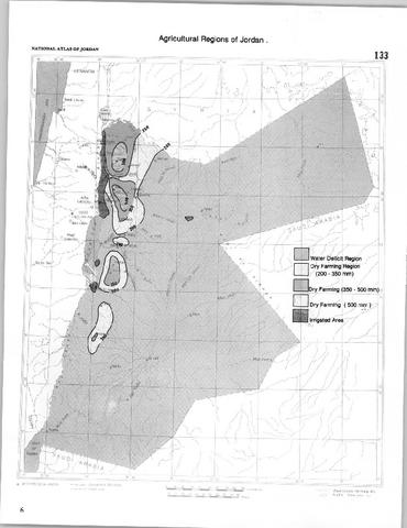
74. [Image] Jordan - Summary of Aquifer Charcteristics
-
75. [Image] Part I: Geological Structure and Relief
-
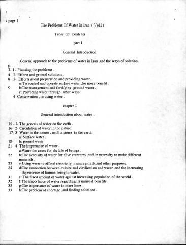
76. [Image] Problems of Water in Iran (Vol. 1-2)
-
79. [Image] Developing Pumps for Third World Use
-
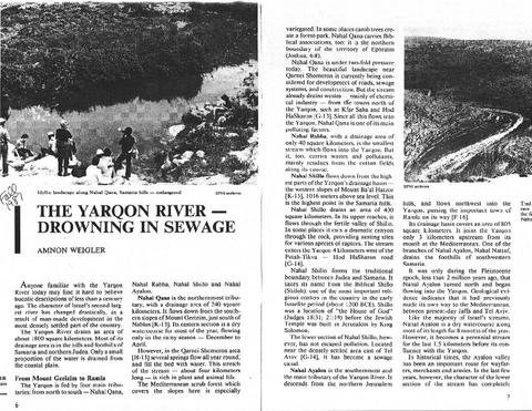
80. [Image] Yarkon River - Drowning in Sewage
-
82. [Image] Introduction a l'Etude du Schema Directeur
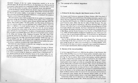
-
83. [Image] Concept of a Sinistral Megashear
-
84. [Image] Economic analysis
-
85. [Image] Special Subjects and Investigations
-
86. [Image] Miscellaneous -- appendices?
-
88. [Image] Irrigation of Sandy Soils
-
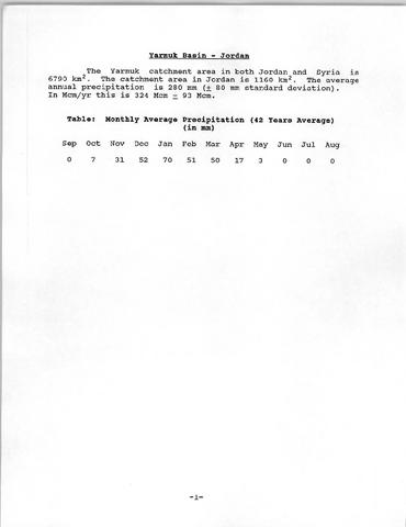
89. [Image] Yarmouk Basin
-
90. [Image] Overall River System of the Middle East
-
91. [Image] Israel and Borderlands: Reference Maps
-
92. [Image] Jordan River Report Appendices -- Originals
-
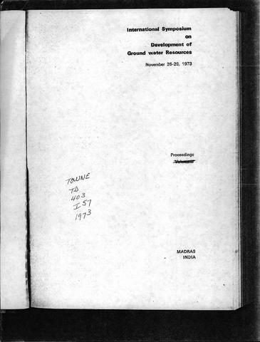
93. [Image] Volume 1, Proceedings
-
94. [Image] Table of contents
-
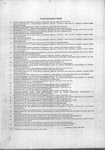
95. [Image] Water Resources Series
-
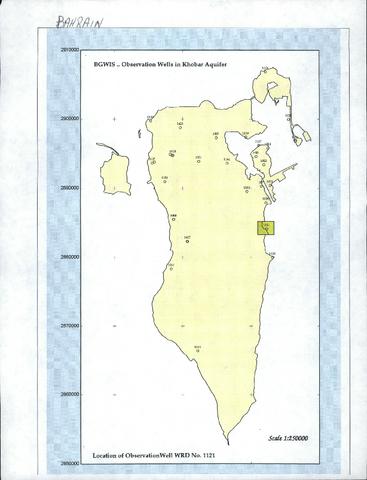
96. [Image] Map of Observation Wells in Khobar Aquifer
-
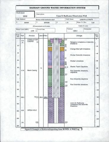
97. [Image] Umm Er Radhuma Observation Well
-
98. [Image] Interview, with land use map
-
99. [Image] IHP Information
-
100. [Image] International Hydrological Programme