Search
You searched for:
Start Over
Pleistocene
Remove constraint Pleistocene
Material Types
Image
Remove constraint Material Types: Image
1 - 31 of 31
Search Results
-
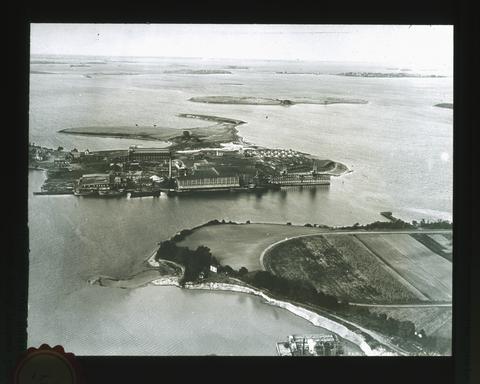 Drumlins, left when the great ice-sheet melted, are seen rising above the waters of the bay. In the Pleistocene epoch (the last geologic epoch before the present time) most of the northern and eastern ...
Citation -
Abstract An abstract of the thesis of Jeffrey Scott Conaway for the Master of Science in Geology presented December 8, 1999. Title: Hydrogeology and Paleohydrology in the Williamson River Basin, Klamath ...
Citation -
Significant results to date include the following: (1) the present Adirondack Mountains Dome is undergoing rapid contemporary vertical doming; the velocity at the center of the dome is 3.7mm/yr, compared ...
Citation -
Since 1978, the Division of Geology and Earth Resources of the Washington Department of Natural Resources has participated in the U.S. Department of Energy's (USDOE) StateCoupled Geothermal Resource Program. ...
Citation -
5. [Image] Petrographic Analysis and Correlation of Volcanic Rocks in Bostic 1-A Well near Mountain Home, Idaho
Detailed examination of volcanic rock cuttings from the Bostic I-A well near Mountain Home, Idaho, provides data that correlate the stratigraphy of the well with the regional stratigraphy of the western ...Citation -
SUMMARY The geology and hydrology of the Basin and Range Province of the western conterminous United States are characterized in a series of data sets depicted in maps compiled for evaluation of prospective ...
Citation -
Fifteen shallow thermal gradient drill holes were recently completed by Geothermal Power Corporation (GPCR) in the vicinity of the Roosevelt Hot Springs KGRA. Five holes penetrated Tertiary granitic rocks ...
Citation -
ill. (some col.), maps ; Thesis (Ph. D.)--Oregon State University, 1972; Includes bibliographical references
Citation -
SUMMARY This report describes the first phase in evaluating the geology and hydrology of the Basin and Range Province for potential suitability of geohydrologic environments for isolation of high-level ...
Citation -
Imprint from transmittal sheet; Distributed to depository libraries in microfiche; Shipping list no.: 97-0071-M; One ill. on 1 folded leaf in pocket; Includes bibliographical references
Citation -
"OF-01-01"
Citation -
12. [Image] A geologic and hydrologic reconnaissance of Lava Beds National Monument and vicinity, California
A GEOLOGIC AND HYDROLOGIC RECONNAISSANCE OF LAVA BEDS NATIONAL MONUMENT AND VICINITY, CALIFORNIA By William R. Hotchkiss ABSTRACT Lava Beds National Monument is on the Modoc Plateau in Modoc and ...Citation -
SUMMARY The U.S. Geological Survey's program for geologic and hydrologic evaluation of physiographic provinces to identify areas potentially suitable for locating repository sites for disposal of high-level ...
Citation -
PURPOSE, SCOPE AND METHODOLOGY A reconnaissance study was designed to collect, compile, and analyze data to determine if ground-water use would interfere with surface water sources near Big Bonanza Springs. ...
Citation -
15. [Image] Nitrogen and phosphorus loading from drained wetlands adjacent to Upper Klamath and Agency Lakes, Oregon
Two maps digitized separately; Includes bibliographical references (p. 44-49)Citation -
16. [Image] Seeking refuge: making space for migratory waterfowl and wetlands along the Pacific Flyway
Abstract "Seeking Refuge" examines the history of migratory waterfowl management along the Pacific Flyway, the westernmost of four main migration routes in North America. Drawing on approaches from historical ...Citation -
17. [Image] Implementation of the Endangered Species Act of 1973 (Report to the House Committee on Resources)
I. Executive Summary There is increasing recognition from most quarters that the Endangered Species Act (ESA) needs to be improved. Exactly what those improvements should be is less uniform. ...Citation -
18. [Image] Historical landscape overview of the upper Klamath River Canyon of Oregon and California
"Submitted to Klamath Falls Resource Area, Bureau of Land Management, Lakeview District, Klamath Falls, Oregon." ; "Contract no.: HAP032021."; Includes bibliographical references (p. 178-200)Citation -
19. [Image] Genetic analysis of Klamath River green sturgeon (acipensar [i.e. acipenser] medirostris)
Abstract The utility of using isozyme analysis to study the stock structure among West Coast populations of green sturgeon (Acipenser medirostris) was assessed. Isozyme analysis was not determined ...Citation -
20. [Image] Programmatic environmental assessment for Klamath Basin Ecosystem Restoration Office Projects, 2000-2010
Programmatic Environmental Assessment Summary This Environmental Assessment (EA) provides compliance with the National Environmental Policy Act (NEPA) for restoration actions undertaken by the US Fish ...Citation -
"Prepared for Klamath Basin Ecosystem Foundation, and the Upper Williamson River Catchment Group, in cooperation with the Upper Klamath Basin Working Group, and the Klamath Watershed Council."
Citation -
TABLE OF CONTENTS PART I INTRODUCTION 18 - 11 History and ethnology 18 Irrigated area table 19 Cultural geography 19 General physiographic features 262e . .3 Physiographic areas and farming 1d CLIMATE ...
Citation -
Abstract The objectives of this two-year study (1998-1999) were to document distribution, abundance, age class structure, recruitment success, and habitat use by all life history stages of shortnose and ...
Citation -
This report presents information on biogeography and broad-scale ecology (macroecology) of selected fungi, lichens, bryophytes, vascular plants, invertebrates, and vertebrates of the interior Columbia ...
Citation -
25. [Image] Lakeview proposed resource management plan and final environmental impact statement [volume 1]
4 v.; maps (some col.); "August 2002"; "January 2003" -- coverCitation -
This report is a review of scientific research done by various organizations involved in the Klamath Reclamation Project to assess the "status and management of coho salmon in the Klamath River and . . ...
Citation -
"April 1998"--P. [4] of cover; Includes bibliographical references (p. 57-66)
Citation -
Quigley, Thomas M.; Arbelbide, Sylvia J., tech. eds. 1997. An assessment of ecosystem components in the interior Columbia basin and portions of the Klamath and Great Basins: volume 1. Gen. Tech. Rep. PNW-GTR-405. ...
Citation -
The Oregon Plan for Salmon and Watersheds Biennial Report 2005-2007. This is the sixth report on the Oregon Plan for Salmon and Watersheds. The report provides an update on the accomplishments and continuing ...
Citation -
30. [Image] Geology and ground-water resources of the Swan Lake-Yonna Valleys area, Klamath County, Oregon
Abstract The Swan Lake-Yonna Valleys area consists of two intermountain valleys with their subordinate side valleys adjoining slopes, and mountainous boundary ridges, In all the area covered is about 256 ...Citation -
We monitored larval Lost River and shortnose suckers from natal beds in the Williamson and Sprague rivers to nursery grounds in Upper Klamath Lake. Downstream movements occurred at night, in the middle ...
Citation