Search
You searched for:
Start Over
Historic stream surveys
Remove constraint Historic stream surveys
Subject
Waterfalls
Remove constraint Subject: Waterfalls
Subject
Rivers -- Washington
Remove constraint Subject: Rivers -- Washington
« Previous | 51 - 60 of 64 | Next »
Search Results
-
51. [Image] Waterfalls on Grays River
 8 foot falls (so-called) below the "Big Slide" on the Grays River. Station 4 is about 4 miles above the Highway. Falls are the only obstruction on river
Citation -
52. [Image] Gail Falls
 Gail Falls on the Cispus River is 200 yards below Cat Creek. The falls are 30 feet high and 8 feet wide
Citation -
53. [Image] Cowlitz Falls
 Cowlitz Falls 8 miles below Randle, Washington
Citation -
54. [Image] Steelhead trout and Indian jump trap
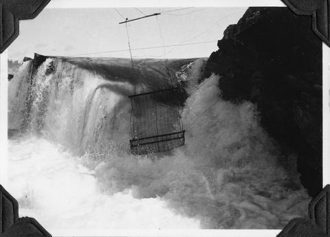 Photo shows Kettle Falls, on the Columbia River, which are now obliterated by the backwater from Grand Coulee Dam
Citation -
55. [Image] Horseshoe Falls
-
56. [Image] Steelhead trout and Indian jump trap
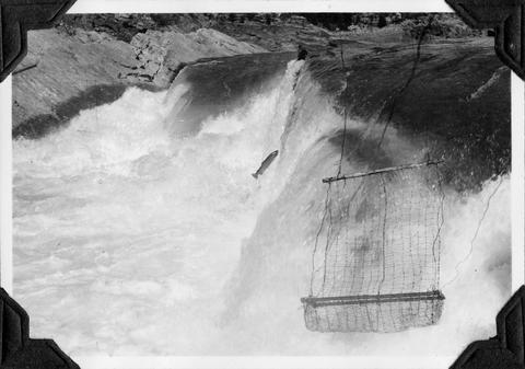 Photo shows Kettle Falls, on the Columbia River, which are now obliterated by the backwater from Grand Coulee Dam
Citation -
57. [Image] Steelhead trout and Indian jump trap
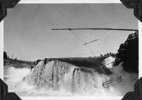 Photo shows Kettle Falls, on the Columbia River, which are now obliterated by the backwater from Grand Coulee Dam
Citation -
58. [Image] Steelhead trout and Indian jump trap
 Photo shows Kettle Falls, on the Columbia River, which are now obliterated by the backwater from Grand Coulee Dam
Citation -
59. [Image] Cispus River falls and cascades
 Part of falls and cascades on the Cispus River below Gail Falls near the Cob Creek confluence
Citation -
60. [Image] Fish tail falls
 Fish tail falls near Silver Creek on the Entiat River
Citation
