Search
You searched for:
Start Over
Tualatin River Watershed
Remove constraint Tualatin River Watershed
Subject
Hydrology
Remove constraint Subject: Hydrology
« Previous | 1 - 10 of 44 | Next »
Search Results
-
The State of Oregon Department of Environmental Quality (DEQ) is developing a TMDL for temperature in the Willamette River basin shown in Figure 1. The study area included the Willamette River and all ...
Citation -
The State of Oregon Department of Environmental Quality (DEQ) is developing a TMDL for temperature in the Willamette River basin shown in Figure 1. The study area included the Willamette River and all ...
Citation -
The State of Oregon Department of Environmental Quality (DEQ) is developing a TMDL for temperature in the Willamette River basin shown in Figure 1. The study area included the Willamette River and all ...
Citation -
The Tualatin River Basin is located in the Washington County, Oregon. The river was detected having high chlorophyll a concentration and low dissolved oxygen concentration during summer time, which violated ...
Citation -
The study area for this assessment is composed of the Alsea, Salmon, Siletz, Yachats, and Yaquina River watersheds and those watersheds that drain directly to the ocean between Cascade Head and Cape Creek ...
Citation -
6. [Article] Green River CE-QUAL-W2 Project: A Hydrodynamic and Water Quality Study of the Green River King County, Washington
This report describes the data processing and model calibration performed for a hydrodynamic and water quality model of the Green River, located in King County, Washington. Figure 1 shows the location ...Citation -
7. [Article] The Bull Run River–Reservoir System Model
The Bull Run watershed is located 41.8 kilometers east of Portland, Oregon in the Mt. Hood National Forest and consists of two reservoirs supplying drinking water to over 840,000 people in the Portland ...Citation -
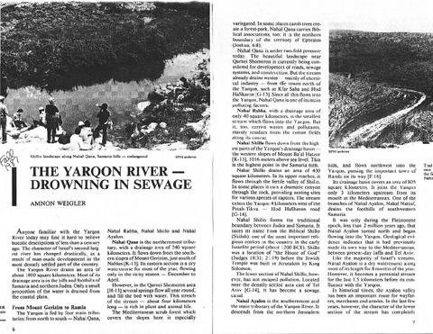
8. [Image] Yarkon River - Drowning in Sewage
-
10. [Image] Jordan River Report Appendices -- Originals