Search
You searched for:
Start Over
Water flow
Remove constraint Water flow
Subject
Hydrology
Remove constraint Subject: Hydrology
1 - 56 of 56
Search Results
-
1. [Article] Investigations into the Regional and Local Timescale Variations of Subglacial Drainage Networks
Subglacial water plays an important role in the regulation of an ice sheet's mass balance. It may be the dominant control on the velocities of ice streams and outlet glaciers on scales of months to millennia. ...Citation -
2. [Article] Analysis and numerical simulation of the ground water system at the Bonneville navigation lock site, Oregon
As part of the new navigation lock for Bonneville Dam a new water source for the Bonneville Fish Hatchery must be supplied. The hatchery is located on the Oregon side of the Columbia River downstream of ...Citation -
3. [Article] Water quality effects of hyporheic processing
"PB2000-107420."Citation -
The Washington Department of Ecology is interested in a water quality model for the Upper Spokane River system for use in developing Total Maximum Daily Loads (TMDLs). The goals of this modeling effort ...
Citation -
The Washington Department of Ecology is interested in a water quality model for the Upper Spokane River system for use in developing Total Maximum Daily Loads (TMDLs). The goals of this modeling effort ...
Citation -
The Washington Department of Ecology is interested in a water quality model for the Upper Spokane River system for use in developing Total Maximum Daily Loads (TMDLs). The goals of this modeling effort ...
Citation -
The objectives of this project were to: • Develop a hydrodynamic and temperature model of Pend Oreille River using CE-QUAL-W2 Version 3.2 • Calibrate the CE-QUAL-W2 model to field data collected during ...
Citation -
8. [Article] Hydrologic and Land Cover Effects on Sources and Fate of In-Stream Fluorescent Dissolved Organic Matter
Dissolved organic matter (DOM) is a critical component of the carbon cycle linking terrestrial and aquatic ecosystems. Although many factors influence DOM fluxes and quality in rivers, controls on DOM ...Citation -
9. [Article] Inter-relationships of vegetation, hydrology and micro-climate in a young, Douglas-fir forest
The links between forests, streamflow, and climate are poorly understood. Despite hundreds of studies over the past 60 years, fundamental questions of forests' effects on the hydrologic cycle remain unanswered. ...Citation -
Engineered capillary barriers typically consist of two layers of granular materials designed so that the contrast in sediment hydrologic properties and sloping interface retains infiltrating water in the ...
Citation -
11. [Article] Lower Willamette River Model: Model Calibration
Water Environment Services of Clackamas County is in the process of planning upgrades on several of its wastewater treatment plants (WWTPs) which discharge into the Lower Willamette River. The goals of ...Citation -
Water Environment Services of Clackamas County is in the process of planning upgrades on several of its sewage treatment plants which discharge into the Lower Willamette River. The goals of the modeling ...
Citation -
13. [Article] Modeling Macrophytes of the Columbia Slough, Oregon
The Columbia Slough is a tidally influenced freshwater system of wetlands, channels, and lakes located within the Portland, Oregon metropolitan area at the confluence of the Willamette and Columbia Rivers. ...Citation -
The Spokane River in Idaho originates in Coeur d’Alene Lake (Figure 1 and Figure 2). The section of the Spokane River from Coeur d’Alene Lake to the Washington state line is the subject of a water quality ...
Citation -
Natural and anthropogenic processes over the past 150 years have altered the bathymetry of the Lower Columbia River (LCR) and have changed the long wave propagation of tides and floods. Possible causes ...
Citation -
16. [Article] Upper Spokane River Model: Model Calibration, 2001
The Upper Spokane River system under consideration is located in the Northeastern part of Washington State and runs from the Stateline with Idaho, River mile (RM) 96.0, downstream to Long Lake dam at RM ...Citation -
17. [Article] Upper Spokane River Model in Idaho: Boundary Conditions and Model Setup and Calibration for 2001 and 2004
As a result of a Total Maximum Daily Load (TMDL) study of the Spokane River in Washington, a hydrodynamic and water quality model for the Spokane River was developed by Portland State University (PSU) ...Citation -
19. [Article] A macroscale measurement and modeling approach to improve understanding of the hydrology of steep, forested hillslopes
The dominant controls on flow generation in steep, forested hillslopes are poorly understood. This dissertation examined the dominant flow processes operating at the hillslope scale, using a combined ...Citation -
20. [Image] Stream Flow Gauging
-
21. [Image] Unsteady Flow and Fluid Transients
-
This is the publisher’s final pdf. The published article is copyrighted by American Geophysical Union and can be found at: http://sites.agu.org/.
Citation -
23. [Article] Modeling Density Currents in Circular Clarifiers
Design of sedimentation tanks for solid-liquid separation is often dependent on assuming ideal flow conditions. But the geometry of the tank and density currents as a result of temperature and suspended ...Citation -
24. [Article] A Novel Approach to Flow Estimation in Tidal Rivers
Reliable estimation of river discharge to the ocean from large tidal rivers is vital for water resources management and climate analyses. Due to the difficulties inherent in measuring tidal-river discharge, ...Citation -
This study was undertaken to gain further understanding of the subsurface hydrology for a stream-adjacent riparian area in Western Oregon's Coast Range. Spatial and temporal fluctuations of the free water surface ...
Citation -
Global climate change is expected to exaggerate the severity of floods and droughts and increase the frequency of extreme streamflow events in the Midwestern United States. Managing these projected impacts ...
Citation -
The focus of this present study is to perform the following tasks: * Develop a hydrodynamic and water quality model of the reservoir formed by the Amaila Falls Hydroelectric Project * Develop and run modeling ...
Citation -
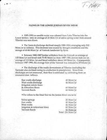
29. [Image] Flows in the Lower Jordan River 1985-1990
-
31. [Article] Integrated hydrologic and hydrochemical observations of Hidden Creek Lake jökulhlaups, Kennicott Glacier, Alaska
Hidden Creek Lake (HCL), an ice-marginal lake impounded by Kennicott Glacier, Wrangell Mountains, Alaska, fills annually to ~20 to 30 x ~10⁶ m³ and then drains subglacially within 2 to 3 days. During the ...Citation -
32. [Article] Validation of the CE-QUAL-W2 Version 3 River Basin Hydrodynamic and Water Quality Model
CE-QUAL-W2 Version 3, a 2-D (longitudinal-vertical) hydrodynamic and water quality model for river basins combining both river and stratified river-estuary and lakereservoir flow, is a development product ...Citation -
CE-QUAL-W2 Version 3, a 2-D (longitudinal-vertical) hydrodynamic and water quality model for river basins combining both river and stratified river-estuary and lake-reservoir flow, is a development product ...
Citation -
34. [Article] TMDLS: Statistical Correlations or Mechanistic Modeling?
Western Idaho and Eastern Oregon, determinations of the assimilative capacity of the system and the impact of pollutant reduction strategies has been performed using both a statistical-correlation approach ...Citation -
35. [Article] Green River CE-QUAL-W2 Project: A Hydrodynamic and Water Quality Study of the Green River King County, Washington
This report describes the data processing and model calibration performed for a hydrodynamic and water quality model of the Green River, located in King County, Washington. Figure 1 shows the location ...Citation -
Spatially varying water-level regimes are a factor controlling estuarine and tidal-fluvial wetland vegetation patterns. As described in Part I, water levels in the Lower Columbia River and estuary (LCRE) ...
Citation -
To the best of our knowledge, one or more authors of this paper were federal employees when contributing to this work. This is the publisher’s final pdf. The published article is copyrighted by Elsevier ...
Citation -
Streamflow response to rainfall is controlled by the net water budget and the routing of rainfall to stream channels. In rain-dominated forested regions, including the Oregon Coast Range, water budget ...
Citation -
41. [Article] TMDLS: Statistical Correlations or Mechanistic Modeling?
In developing TMDL waste-load allocations for the Snake River-Reservoir system in Western Idaho and Eastern Oregon, determinations of the assimilative capacity of the system and the impact of pollutant ...Citation -
Stream temperatures are affected by multiple forcing functions, including surface heat exchange (including solar radiation, evaporation, conduction, and net long wave radiation) and hyporheic flows. Each ...
Citation -
43. [Article] A Stable Isotopic Investigation of a Polar Desert Hydrologic System, McMurdo Dry Valleys, Antarctica
The hydrologic system of the coastal McMurdo Dry Valleys, Antarctica, is defined by snow accumulation, glacier melt, stream flow, and retention in closed-basin, ice-covered lakes. During the austral summers ...Citation -
44. [Article] Convergent Surface Water Distributions in U.S. Cities
Earth's surface is rapidly urbanizing, resulting in dramatic changes in the abundance, distribution and character of surface water features in urban landscapes. However,the scope and consequences of surface ...Citation -
Dutch Canyon is located directly west of the City of Scappoose in Columbia County Oregon. This area is proximate to Highway 30, a major access corridor to downtown Portland, and is experiencing a population ...
Citation -
46. [Article] Hydrogeologic Investigation of a Pumice Aquifer, Fremont/Winema National Forest, Oregon
The middle Holocene cataclysmic eruption of Mount Mazama blanketed Walker Rim, in south central Oregon, with 270 cm to 300 cm of pumice, causing capture of surface water systems by groundwater, stream ...Citation -
The geothermal reservoir modeling effort at the University of Colorado is reviewed briefly. Technical accomplishments during the final funding period 1 April 1978 to 30 November 1978 are described. It ...
Citation -
Subaerial fallout from the Holocene eruption of Mount Mazama in the Oregon Cascade Range was deposited upon relatively low permeability volcanic and volcaniclastic bedrock and regolith. In the Walker Rim ...
Citation -
Capture of stormwater particulate matter is of concern to watershed managers trying to meet water quality guidelines by removing toxics associated with particulates from natural water bodies. A laboratory ...
Citation -
50. [Article] The Influence of Floodplain Restoration on Flow and Sediment Dynamics in an Urban River
A study of floodplain sedimentation on a recently restored floodplain is presented. This study uses a two-dimensional hydro-morphodynamic model for predicting flow and suspended-sediment dynamics in the ...Citation -
Vertisols and other vertic-intergrade soils are found all over the globe, including many agricultural and urban areas. These soils are characterized by their cyclical shrinking and swelling behaviors, ...
Citation -
The State of Oregon Department of Environmental Quality (DEQ) is developing a TMDL for temperature in the Willamette River basin shown in Figure 1. The study area included the Willamette River and all ...
Citation -
The State of Oregon Department of Environmental Quality (DEQ) is developing a TMDL for temperature in the Willamette River basin shown in Figure 1. The study area included the Willamette River and all ...
Citation -
54. [Article] Streamflow Modeling of Johnson Creek Subwatersheds Using the Precipitation Runoff Modeling System
Johnson Creek, in the Portland, Oregon metropolitan region, has several pollutants on the U.S. Environmental Protection Agency’s (EPA) 303(d) list including excess heat, low dissolved oxygen, and harmful ...Citation -
The State of Oregon Department of Environmental Quality (DEQ) is developing a TMDL for temperature in the Willamette River basin shown in Figure 1. The study area included the Willamette River and all ...
Citation -
The Columbia River Littoral Cell (CRLC), a high-wave-energy littoral system, extends 160 km alongshore, generally north of the large Columbia River, and 10–15 km in across-shelf distance from paleo-beach ...
Citation