Search
You searched for:
Start Over
Historic stream surveys
Remove constraint Historic stream surveys
Subject
Dams
Remove constraint Subject: Dams
« Previous | 301 - 400 of 436 | Next »
Search Results
-
301. [Image] Screens and grizzly
 Screens and "grizzly" in Wapato Project diversion
Citation -
302. [Image] Grimes Pass Dam
 Grimes Pass Dam on the South Fork Payette River, Idaho
Citation -
303. [Image] Galloway dam across Weiser River
 Galloway dam across Weiser River above town of Weiser, Idaho. In a normal summer there is no water in the river channel below here
Citation -
304. [Image] Chinooks in brail
 Chinooks in brail in the south trap at Rock Island Dam
Citation -
305. [Image] Tunnels from collecting pool to brail
 Tunnels from collecting pool to brail, on left trap, at the Rock Island Dam in the spring
Citation -
306. [Image] Rock Island Dam
 Rock Island dam showing central spillway and west trap and fishway
Citation -
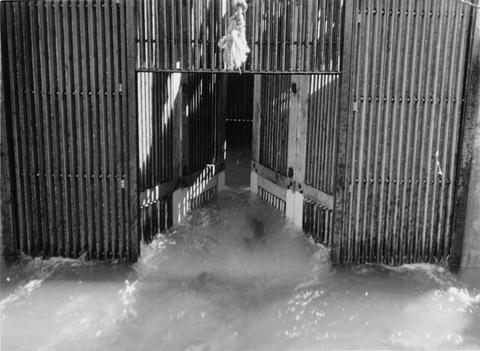
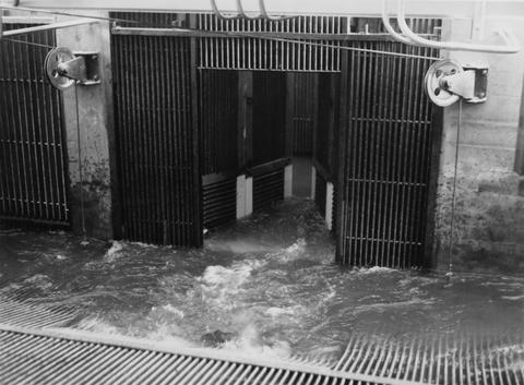
307. [Image] Collecting pool at trap at Rock Island Dam
-
308. [Image] Temporary fish ladder
 Temporary ladder on the Oregon side of the Bonneville Dam
Citation -
309. [Image] Releasing marked fish
 Releasing marked fish above Bonneville Dam with the anal and right vental removed
Citation -
310. [Image] Releasing marked fish
 Releasing marked fish above Bonneville Dam with the anal and right vental removed
Citation -
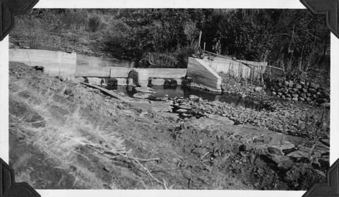
311. [Image] Mann Creek dam and diversion
 Dam and diversion on Mann Creek just above the Harold Beecher dam. About 1 cubic foot per second is escaping under flash boards. Pool above dam is heavily covered with algae. It is a low water barrier ...
Citation -
312. [Image] Mann Creek dam and diversion
 Dam and diversion on Mann Creek just above the Harold Beecher dam. About 1 cubic foot per second is escaping under flash boards. Pool above dam is heavily covered with algae. It is a low water barrier ...
Citation -
313. [Image] Mann Creek temporary diversion dam
 Temporary diversion dam on Mann Creek 1300 yards below US 95 bridge. The dam takes all water, approximately 1 cubic foot per second, which seeps through dam Another dam, 150 yards below, diverts the ...
Citation -
314. [Image] Warrenton water supply dam
 City of Warrenton water supply dam on the Lewis and Clark River. The main dam which was far below this washed out and was to be rebuilt in 1946
Citation -
315. [Image] Warrenton water supply
 City of Warrenton water supply dam on the Lewis and Clark River. ;The main dam washed out and was to be rebuilt in 1946. The dam will have a fish ladder
Citation -
317. [Image] Lumber mill dam at Carlton, Oregon
 Lumber mill dam on North Fork Yamhill River. Dam is an obstruction to migratory fish
Citation -
318. [Image] Black Canyon Dam and flume
-
319. [Image] Black Canyon Dam and flume
-
320. [Image] Catherine Creek diversion dam
 Catherine Creek water supply diversion dam for city of Union, Oregon. Shows low water barrier
Citation -
321. [Image] Dam at Oregon state hatchery
 Dam at Oregon state hatchery on the North Fork Klaskanine River
Citation -
322. [Image] Dam at outlet of Payette Lake
 Dam at outlet of Payette Lake on the North Fork Payette River
Citation -
323. [Image] Black Canyon dam
 Black Canyon dam on the Payette River
Citation -
324. [Image] Grande Ronde River power diversion dam
 Grande Ronde River showing power diversion at point between La Grande and Island City. Supplies water power to flour mill in Island City. No protective devices and no by-pass
Citation -
325. [Image] Black Canyon Dam spillway
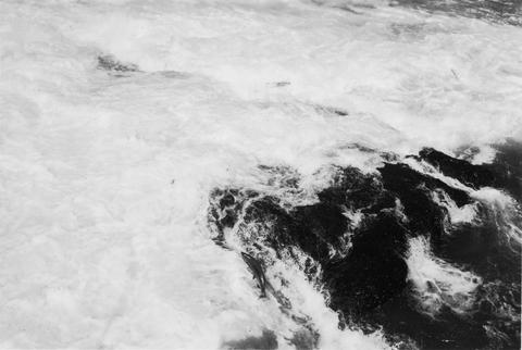
 Water at foot of spill
Citation -
326. [Image] Power diversion dam across Grande Ronde River
 Grande Ronde River with power diversion dam completely across the river. It is a barrier for fish at low water when only seepage escapes downstream. Dam is located between La Grande and Island City, Oregon ...
Citation -
327. [Image] Dam above Little Payette Lake
 Dam above Little Payette Lake maintained by McCall Power Company. Little Payette Lake is a tributary to North Fork Payette River.
Citation -
328. [Image] Dam above Little Payette Lake
 Little Payette Lake is a tributary to North Fork Payette River.
Citation -
329. [Image] South Fork Burnt River
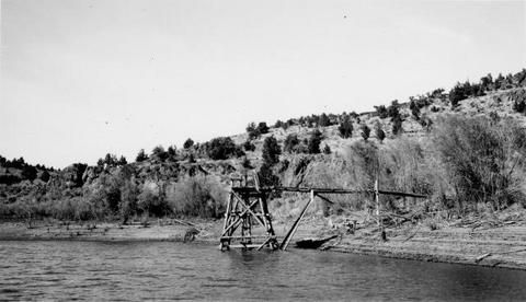 Photo shows old dirt dam at lower end of upper reservoir and underwater outlet from reservoir. Dam is controlled by gate operated from tower
Citation -
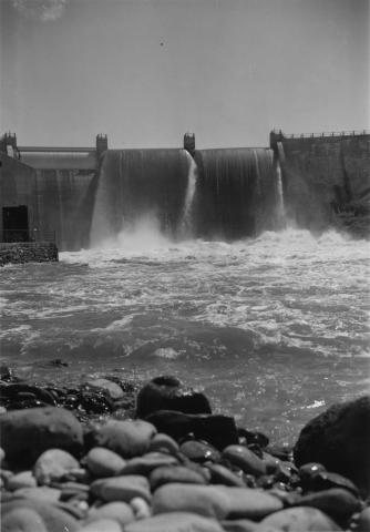
330. [Image] Black Canyon dam
 Payette River below Black Canyon Dam
Citation -
331. [Image] Black Canyon dam
 Black Canyon dam on the Payette River
Citation -
332. [Image] Black Canyon dam
 Black Canyon dam on the Payette River
Citation -
333. [Image] Black Canyon dam
 Black Canyon dam on the Payette River
Citation -
335. [Image] Washougal River
 Washougal River at an upstream power dam which shows a new fish ladder
Citation -
336. [Image] North Fork Burnt River irrigation diversion
 Photo shows irrigation diversion, almost completely diverting flow
Citation -
337. [Image] Dam on North Fork Payette River at McCall, Idaho
-
338. [Image] Moxee headgates
 Uppermost headgates on Moxee Ditch
Citation -
339. [Image] Moxee Ditch second headgates
 Second headgates at Moxee Ditch at county road dike. Moxee Diversion
Citation -
340. [Image] Sunnyside ditch headgates
 Downstream view of Sunnyside ditch headgates. Sunnyside Project
Citation -
341. [Image] Sunnyside dam
 Downstream view of rotary screens. Sunnyside Project
Citation -
342. [Image] Wallowa Lake dam
 Downstream view of dam at outlet of Wallowa Lake. Large pipe in foreground conveys water to power plant at Joseph, Oregon
Citation -
343. [Image] Diversion dam for Cove power canal
 Diversion dam on Crooked River for Cove power canal
Citation -
344. [Image] Powerhouse and fish ladder
 Powerhouse and fish ladder in dam at outlet of Suttle Lake
Citation -
345. [Image] Swimming pool dam at Lake Creek Lodge
 Lake Creek is a tributary of Metolius River
Citation -
346. [Image] Screens and grizzly
 Screens and grizzly in Cascade Lumber Company flume taking off from the Naches River, a tributary of the Yakima River
Citation -
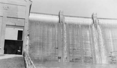
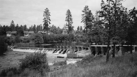
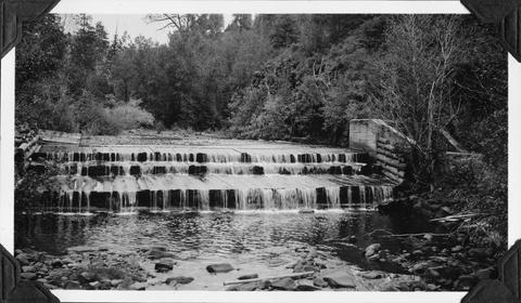
347. [Image] Richland Dam
 Richland dam near mouth of Yakima River
Citation -
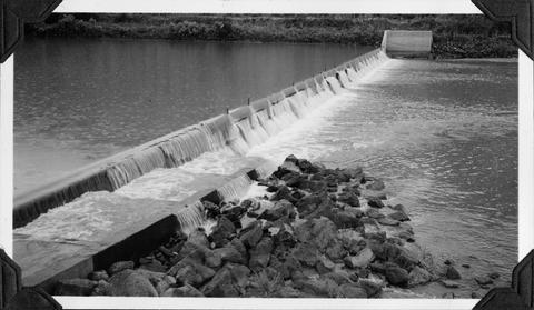
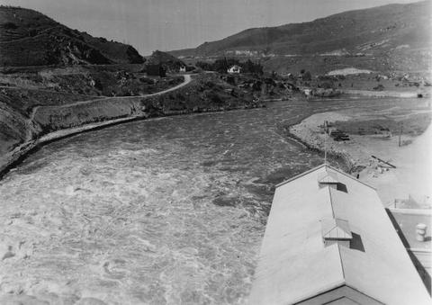
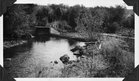
349. [Image] North Canal Dam
 North Canal dam at northern city limits of Bend, Oregon on the Deschutes River
Citation -
350. [Image] Deschutes River irrigation dam
 Deschutes River irrigation dam 1/4 mile below the Pacific, Power and Lights dam in Bend, Oregon
Citation -
351. [Image] Falls and log jam
 Falls and log jam in Little Wenatchee River beyond which the bluebacks, chinooks, steelheads, "silvers," etc could not migrate in 1939
Citation -
352. [Image] Richland Dam
 Richland Dam near mouth of the Yakima River
Citation -
353. [Image] Chinooks jumping over middle rocks
 Rock Island Dam
Citation -
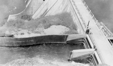
354. [Image] Washington Water Power dam and ladder
 Front view of dam
Citation -
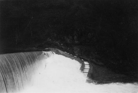
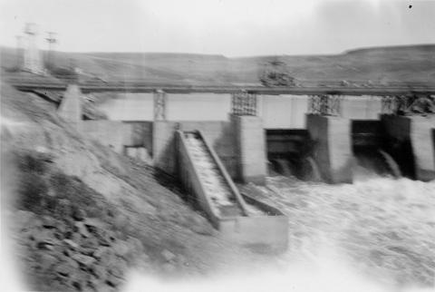
355. [Image] Lewiston Dam weir
 Lewiston Dam weir on the Clearwater River
Citation -
356. [Image] Diversion Dam below Troutdale, Oregon
-
357. [Image] Whiteleather and Hanavan talking to damkeeper
 Lewiston Dam on the Clearwater River near Lewiston, Idaho
Citation -
358. [Image] Galloway Dam and fish ladder
-
359. [Image] Tunnels from collecting pool
 Tunnels from collecting pool into brail at east trap at the Rock Island Dam
Citation -
360. [Image] Chinooks jumping rock
 Chinooks jumping rock left of middle ladder at Rock Island Dam
Citation -
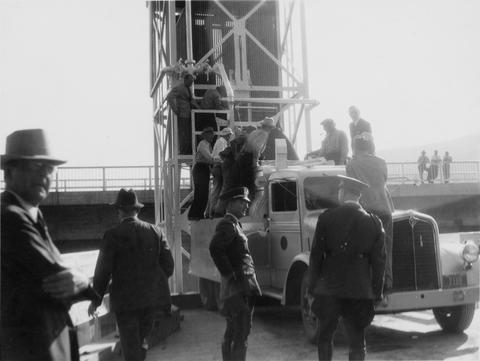
361. [Image] First fish haul
 Left trap at Rock Island Dam. Washington Governor Clarence Daniel Martin on truck
Citation -
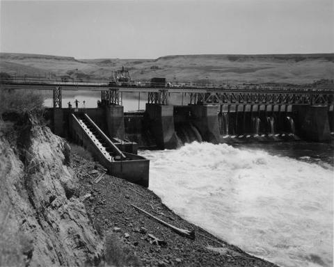
362. [Image] Rock Island Dam
 Rock Island dam showing the central spillway, west trap and fishway
Citation -
363. [Image] Sandy River
 Big Sandy Channel dam in far background
Citation -
364. [Image] Rock Island Dam
 Rock Island Dam on the Columbia River
Citation -
365. [Image] Sawmill Dam
-
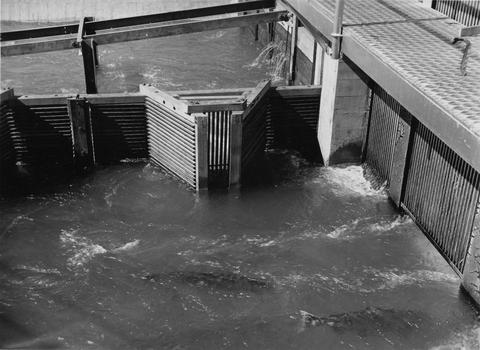
366. [Image] Gate into hoist of fish trap
 Gate into hoist of fish trap at Rock Island Dam
Citation -
367. [Image] Central fish hoist and elevator
 Central fish hoist at Rock Island Dam
Citation -
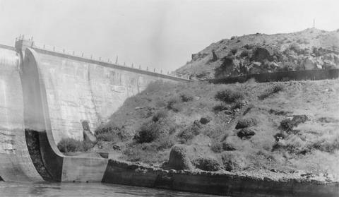
368. [Image] Black Canyon Dam
 Black Canyon Dam on the Payette River in Idaho
Citation -
369. [Image] Mann Creek dam and diversion
 Dam and diversion on Mann Creek just below the site of the new dam
Citation -
371. [Image] Salmon entering elevator from brail
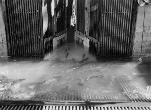 Rock Island Dam
Citation -
372. [Image] Putting water in fish truck
 Putting water in fish truck showing hatch on fish tank at the Rock Island Dam
Citation -
373. [Image] Headgate on Union Gap Ditch
 Second headgate on Union Gap Ditch near county road dike . Union Gap Diversion
Citation -
374. [Image] Rock Island Dam fish loads
 First load of Chinooks and Steelheads at the left (east) trap
Citation -
375. [Image] Salmon going from brail through tunnel to elevator
 Left trap at the Rock Island Dam during the summer
Citation -
376. [Image] Mill ditch dam on Weiser River
 Dam for mill ditch on main Weiser River above town of Weiser, Idaho Normally there is no water in this part of the river in summer Nine cubic feet per second is then diverted from the Galloway Ditch into ...
Citation -
377. [Image] Mesa dam and ditch take-off
 Mesa dam and ditch take-off on Middle Fork Weiser River about 7 miles by road above US 95. Low water barrier to fish. In a normal summer the river is dry from here to the mouth
Citation -
378. [Image] Bull Run diversion
 Portland water department Bull Run diversion
Citation -
379. [Image] Bull Run River
 Bull Run River below Portland Water Department dam
Citation -
380. [Image] Screen in Middy Ditch
 Screen in Middy Ditch near Union Gap screens. Moxee Diversion
Citation -
381. [Image] Middy Ditch
 Upper screen on Middy Ditch, just below Rosa by pass. " Moxee Diversion"
Citation -
382. [Image] Dam on Indian Creek
 Dam on Indian Creek forms water supply reservoir for city of Elgin, Oregon
Citation -
383. [Image] Separation of Moxee Ditch
 Separation of Moxee ditch into Ray Slavin (left) and Middy ditches . Moxee Diversion
Citation -
384. [Image] Screen in Middy Ditch
 Screens in Middy Ditch near the Union Gap screens. The Middy Ditch divides into 3 channels at this point, each with a rotary screen. Moxee Diversion
Citation -
385. [Image] Rotary screen and grizzly
 Rotary Screen and "grizzly on Selah-Moxee ditch. Selah-Moxee Diversion
Citation -
386. [Image] Selah-Moxee Ditch screens and headgates
 Screens and lower headgates and by-pass on Selah-Moxee ditch. Selah-Moxee Diversion
Citation -
387. [Image] Filling fish truck
 Filling a fish truck at the east trap at Rock Island Dam
Citation -
388. [Image] Weiser River galloway dam
 Galloway dam across Weiser River above town of Weiser, Idaho
Citation -
389. [Image] Chinook jumping rock
 Chinook jumping rock left of middle ladder at the Rock Island Dam
Citation -
390. [Image] Salmon on counting board
 Salmon on counting board between brail and elevator at the Rock Island Dam
Citation -
391. [Image] Salmon on counting board
 Salmon on counting board between brail and elevator at the Rock Island Dam
Citation -
392. [Image] Mesa dam and ditch take-off
 Mesa dam and ditch take-off on Middle Fork Weiser River, Idaho located about 7 miles by road above US 95. It is a low water barrier to fish. In a normal summer the river is dry from here to the mouth
Citation -
393. [Image] Mann Creek dam and diversion
 Irrigation dam and diversion just below the site for the new irrigation dam. Low water is a barrier to fish
Citation -
394. [Image] Loading fish truck at left trap
 Rock Island Dam during spring
Citation -
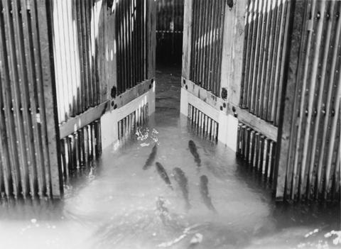
395. [Image] Salmon entering elevator from brail
 Rock Island Dam
Citation -
396. [Image] Salmon Trap with brail raised
 Rock Island Dam
Citation -
397. [Image] Bull Run diversion
 Portland water department Bull Run diversion
Citation -
398. [Image] Chinook jumping rock
 Chinook jumping rock left of middle ladder at the Rock Island Dam
Citation -
399. [Image] Black Canyon Dam
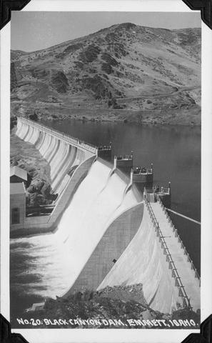 Black Canyon Dam near Emmett, Idaho
Citation -
400. [Image] Screens and headgates
 Screen and headgates on Middy ditch just beyond the Rosa ditch by-pass
Citation