Search
Search Results
-
61. [Image] Lecanora confusa
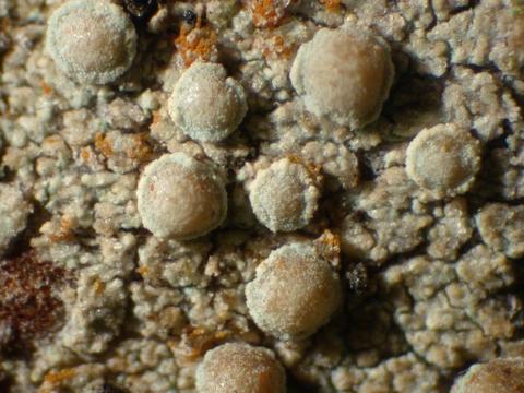 Apothecia; Habitat: Mixed riparian forest; Location: The Dell, 3 km S of Tenmile, by Degnath Creek; Substrate: Bark, Pseudotsuga trunk; Elevation: 400 meters.
Citation -
62. [Image] Lecanora confusa
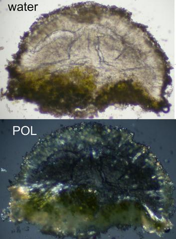 Apothecial section; Habitat: Mixed riparian forest; Location: The Dell, 3 km S of Tenmile, by Degnath Creek; Substrate: Bark, Pseudotsuga trunk; Elevation: 400 meters.
Citation -
prepared in cooperation with the Bureau of Reclamation; Also available via Internet as PDF file through Southern Oregon Digital Archives: http://soda.sou.edu. Search Bioregion Collection.
Citation Citation
- Title:
- A selected bibliography of water related research in the upper Klamath Basin, Oregon
- Author:
- Brownell, Dorie Lynn and Mia R. Renallo
- Year:
- 1995, 2011, 2013
prepared in cooperation with the Bureau of Reclamation; Also available via Internet as PDF file through Southern Oregon Digital Archives: http://soda.sou.edu. Search Bioregion Collection.
-
64. [Image] Gerber-Willow Valley Watershed Analysis
x, 386 p., ill., maps (some col.); Cover title; "July 2003"Citation Citation
- Title:
- Gerber-Willow Valley Watershed Analysis
- Author:
- U.S. Department of the Interior. Bureau of Land Management; Klamath Falls Resource Area Office; U.S. Department of Agriculture. Forest Service; Fremont-Winema National Forests; Modoc National Forest
- Year:
- 2003, 2006, 2005
x, 386 p., ill., maps (some col.); Cover title; "July 2003"
-
65. [Image] Programmatic environmental assessment for Klamath Basin Ecosystem Restoration Office Projects, 2000-2010
Programmatic Environmental Assessment Summary This Environmental Assessment (EA) provides compliance with the National Environmental Policy Act (NEPA) for restoration actions undertaken by the US Fish ...Citation Citation
- Title:
- Programmatic environmental assessment for Klamath Basin Ecosystem Restoration Office Projects, 2000-2010
- Author:
- U.S. Fish and Wildlife Service. Klamath Basin Ecosystem Restoration Office.
- Year:
- 2000, 2005, 2004
Programmatic Environmental Assessment Summary This Environmental Assessment (EA) provides compliance with the National Environmental Policy Act (NEPA) for restoration actions undertaken by the US Fish & Wildlife Service's Klamath Basin Ecosystem Restoration Office (ERO) in Klamath Falls, Oregon. These restoration activities are needed due to the large-scale loss of wetland and riparian habitat and degraded water quality. The purpose of these restoration efforts is the improvement of conditions of the watershed with specific regard to habitat and water quality, resulting in, among other benefits, improved conditions for the endangered fish species (bull trout and Lost River and shortnose sucker) populations of the basin. The geographic scope of this EA is defined as the upper Klamath River basin, including the entire watershed from Irongate Dam upstream to the headwaters. This EA is intended to provide NEPA compliance for restoration projects conducted between the years 2000 and 2010. The ERO was established in 1993 to sponsor and assist with a variety of restoration activities in the Klamath Basin. The ERO funds and provides technical assistance to restoration projects involving private landholders, concerned groups, and other state, federal, and tribal agencies. Four alternatives are presented in this EA. The proposed alternative (Alternative 1) consists of a comprehensive program of ecosystem restoration, promoting projects in both riparian areas and in upland habitats. This would continue the current program in effect since 1994. NEPA compliance would primarily be carried out via a single, programmatic document saving time and funds. The Fish & Wildlife Service proposes to fund and administer the following projects types: Riparian Projects: (fencing for livestock management; native plant establishment & diversification; non-native plant removal/control; erosion control; contour re-establishment; impoundment removal; wildlife habitat improvements) Wetland Projects: (fencing; wetland restoration and enhancement; wildlife habitat improvements) Upland or Road Projects: (road abandonment, decommissioning, & obliteration; road drainage improvements and storm proofing, re-establishment of historic contours; silvicultural treatments; native plant establishment/diversification; non-native plant removal/control; fencing; landslide treatments; culvert/stream crossing upgrades; erosion control; wildlife habitat improvements). In-stream Projects: (habitat complexity and diversity improvements; hydrologic regime improvements; coarse woody debris supplementation; natural or artificial barrier removal, modification &/or creation; fish screens installation). Alternative 2 would concentrate restoration efforts only on riparian, instream, and wetland areas. Road projects would be conducted only within the riparian corridor, as defined. NEPA compliance would also be conducted programmatically. Alternative 3 would cease all restoration activities conducted and funded by the ERO in the Klamath Basin. This alternative would serve as a benchmark against which the effects of the restoration alternatives discussed above can be compared. Alternative 4, the "No Action" alternative, would continue current management policies with regard to NEPA compliance, providing compliance on a project by project basis requiring independent analysis for each project. The affected environment of the region is described in detail. The environment has been changed significantly since the 1890's due to logging, agriculture and urban development. An extensive system of dams, canals, and drainage structures has resulted in the conversion of approximately 80% of pre-settlement wetlands to agricultural uses. Riparian corridors have been similarly impacted, and upland forests regions have been affected by logging, road construction and other factors. These changes have contributed to problems with the water quality in the region, contributing to the listing of several fish species as threatened or endangered; loss of habitat has affected a large number of other species as well. The environmental effects of each alternative is analyzed. Some short term negative impacts could occur as a result of the projects authorized by both Alternative 1 and Alternative 2, but these would be strongly offset by the expected beneficial results to water quality and habitat conditions. Alternative 1 would be expected to have a greater overall effect on the environment than Alternative 2, since many of the underlying factors with which restoration efforts are concerned originate in upland conditions (i.e. sedimentation and hydrologic functionality). Alternative 3 would result in conditions remaining much as they are currently, although other programs and organizations are making efforts at restoration activities. The environmental impacts of individual projects anticipated under Alternative 4 would be generally the same as for similar projects under Alternative 1. The primary difference between the two alternatives would be the higher efficiency and improved cumulative analysis resulting from a programmatic approach as proposed in Alternative 1. Public participation in the NEPA process has been, and will continue to be, solicited and welcomed. Compliance with state and federal laws and regulations such as the Clean Water Act, National Historic Preservation Act, and the Endangered Species Act, as well as guidelines for contaminant surveys, will be carried out as detailed. While these projects are expected to play an important role in the restoration of the region, none of these alternatives are expected to have a significant impact when compared with the loss of wetland, riparian and upland habitats over the past century, impacts which do occur would be of a cumulatively beneficial nature. Other restoration efforts are being carried out in the area by other governmental and private groups, and it is expected that these combined efforts will achieve important beneficial results for the ecosystem.
-
Abstract The Secretaries of Agriculture and the Interior propose limited changes to language about how to demonstrate that projects follow the Aquatic Conservation Strategy, part of the Northwest Forest ...
Citation Citation
- Title:
- Final supplemental environmental impact statement: for clarification of language in the 1994 record of decision for the Northwest Forest Plan; national forests and Bureau of Land Management districts within the range of the northern spotted owl: proposal to amend wording about the aquatic conservation strategy
- Author:
- United States. Department of Agriculture. Forest Service; United States. Department of the Interior. Bureau of Land Managemen
- Year:
- 2003, 2006, 2005
Abstract The Secretaries of Agriculture and the Interior propose limited changes to language about how to demonstrate that projects follow the Aquatic Conservation Strategy, part of the Northwest Forest Plan. Projects needed to achieve Northwest Forest Plan goals have been delayed or stopped due to misapplication of certain passages in the Aquatic Conservation Strategy. The agencies are responding to the underlying need for increased agency success planning and implementing projects, to the extent that the current wording has hindered the agencies ability to follow Northwest Forest Plan principles and achieve its goals. The goals of the Northwest Forest Plan cannot be achieved without project implementation. Three alternatives are considered in the Final Supplemental Environmental Impact Statement, No Action, the Proposed Action, and Alternative A. No Action would not change existing language within the Aquatic Conservation Strategy. The Proposed Action and Alternative A would make l
-
67. [Image] Upper Klamath Basin : opportunities for conserving and sustaining natural resources on private lands
1 i California Oregon Cover Photo: Lower Klamath National Wildlife Refuge at sunset Tupper Ansel Blake/ USFWS Map Detail Area: Upper Klamath River Basin ii T he Klamath River Basin presents numerous ...Citation Citation
- Title:
- Upper Klamath Basin : opportunities for conserving and sustaining natural resources on private lands
- Author:
- United States. Natural Resources Conservation Service
- Year:
- 2004, 2005
1 i California Oregon Cover Photo: Lower Klamath National Wildlife Refuge at sunset Tupper Ansel Blake/ USFWS Map Detail Area: Upper Klamath River Basin ii T he Klamath River Basin presents numerous challenges as well as opportunities for its many water users. For years, farmers and ranchers in the basin have recognized the vital role they play in the health of their watershed. Working with conservation districts, the Natural Resources Conservation Service ( NRCS) and others, land managers continue to proactively find ways to enhance natural resources in the basin, benefiting wildlife and the environment. However, as it has across the western United States, drought hit home in the Klamath for those who depend on every drop of water to sustain their livelihood, culture and community. In the spring of 2001, the combination of drought and the impact of the Endangered Species Act triggered a shutdown of irrigation water during the growing season, drying up water resources to more than 2,000 farms and ranches. NRCS, in cooperation with local conservation districts, provided a quick infusion of technical assistance and $ 2 million in cost- share funding for cover crops through the Emergency Watershed Protection Program. As cover crops took hold, the seeds of a long- term solution took root in the NRCS/ conservation district partnership. The ability of the local office to receive funding, engage community members and other partners, plan resource improvements, implement actions, and monitor success proved to be an invaluable asset for the community. Helping private landowners develop and apply practical, common- sense solutions to complex resource issues will be the challenge of the conservation partnership well into the future. USDA, in concert with the locally led conservation districts, will continue to play a critical role by delivering technical and financial assistance to Klamath Basin farmers and ranchers. The Rapid Subbasin Assessments that follow are the first step in that process. The assessments are designed to help local decision- makers determine where investments in conservation will best benefit wildlife habitat, agriculture and other land uses in a compatible manner. It is our goal to provide a comprehensive overview of resource challenges and opportunities in the basin, and help decision- makers to prioritize their investments in areas that will best sustain multiple use of natural resources in the basin now and in the future. Sincerely, Robert J. Graham Charles W. Bell, State Conservationist State Conservationist Oregon NRCS California NRCS iii iv Table of Contents Map of the Upper Klamath Basin ................................ i Letter from OR and CA State Conservationists .......... ii Overview of the Upper Klamath Basin ........................ 1 Background ................................................................................... 1 Upper Klamath Basin Description ............................................ 2 The Role of Agriculture in the Basin ........................................ 3 Rapid Subbasin Assessments ...................................................... 4 Private Lands Conservation Accomplishments ...................... 6 Summary of Conservation Opportunities ............................... 7 Water Conservation ...................................................................... 8 Improving Water Quality ........................................................... 10 Increasing Water Storage/ Yield ............................................... 11 Enhancing Fish and Wildlife Habitat ...................................... 12 Overview of Conservation Effectiveness .............................. 13 Comparative Benefit: Water Demand ..................................... 15 Comparative Benefit: Water Quality ....................................... 15 Comparative Benefit: Water Storage/ Yield ............................ 16 Comparative Benefit: Habitat/ Fish Survival .......................... 16 Sprague River Subbasin .............................................. 18 Resource Concerns & Conservation Accomplishments ...... 19 Conservation Opportunities ..................................................... 20 Williamson River Subbasin ......................................... 22 Resource Concerns & Conservation Accomplishments ...... 23 Priority Conservation Opportunities ....................................... 24 Upper Klamath Lake Subbasin .................................. 26 Resource Concerns & Conservation Accomplishments ...... 27 Priority Conservation Opportunities ....................................... 28 Upper Lost River Subbasin ......................................... 30 Resource Concerns & Conservation Accomplishments ...... 31 Priority Conservation Opportunities ....................................... 32 Middle Lost River Subbasin ....................................... 34 Resource Concerns & Conservation Accomplishments ...... 35 Priority Conservation Opportunities ....................................... 36 Tulelake Subbasin ...................................................... 38 Resource Concerns & Conservation Accomplishments ...... 39 Priority Conservation Opportunities ....................................... 40 Butte Valley Subbasin ................................................. 42 Resource Concerns & Conservation Accomplishments ...... 43 Priority Conservation Opportunities ....................................... 44 Upper Klamath River East Subbasin .......................... 46 Resource Concerns & Conservation Accomplishments ...... 47 Priority Conservation Opportunities ....................................... 48 1 Overview of the Upper Klamath Basin Upper Klamath Basin Quick Facts • The Upper Klamath Basin includes the Klamath, Williamson, Sprague, Lost, and Wood rivers, among others • Several state and federal wildlife refuges are a part of the Upper Klamath Basin • Migratory birds like the American White Pelican and the Red- necked Grebe use croplands in the Klamath Basin as a stop on the Pacific Flyway • Deer and elk graze on wheat and barley fields and pheasants use both crop and rangelands for their nesting and feeding grounds Background In a landscape formed by seemingly endless cycles of drought and flood, it’s no wonder that for hundreds of years, competition for water has dominated the landscape of the West. Stretching across southern Oregon and northern California, the Klamath Basin has become synonymous with the water challenges that western water users face. As one example, agricultural commodities that need irrigation water to thrive – providing Americans with the cheapest domestic food supply in the world, face competition from the critical water needs of sucker fish, salmon and other threatened and endangered species. While that competition is understandable, more and more, conservation leaders in all industries have come to recognize that these water needs aren’t necessarily at odds with one another, and can in fact be compatible. While an example of the challenges today’s agricultural producers and conservationists face, the Klamath Basin has emerged as an example of how diverse interests can work together successfully. 2 Overview of the Upper Klamath Basin Upper Klamath Basin Description The Upper Klamath Basin is an area of high desert, wetlands, and the Klamath River. The river extends 250 miles from its headwaters at Upper Klamath Lake in south central Oregon to the west coast of northern California. The Upper Klamath Basin includes the US Bureau of Reclamation’s ( USBR) Klamath Project Area and the drainage area above Irongate Dam on the Klamath River. The basin’s lakes, marshes, and wetlands host an abundance of plant and animal species and include national wildlife refuges, parks, and forests. Agricultural production began around the turn of the 20th century, and with the creation of the Klamath Irrigation District in 1905, water diversions for irrigation began in earnest. A portion of these irrigated lands are in the USBR’s irrigation project. The ‘ project area,’ as it is commonly called, includes 188,000 of the 502,000 acres of private irrigated land in the basin. This includes lands leased from the various wildlife refuges that are supplied with water by the USBR. Privately irrigated acreages can vary from year to year, depending on USBR contracts and annual cropping cycles. In comparison, the majority of the private irrigated land - about 314,000 acres - in the basin is located outside the project area. Upper Klamath Basin Quick Facts: • Over 2.2 million acres are privately owned in the Upper Klamath Basin • 188,000 of the irrigated acres are in the US Bureau of Reclamation’s Irrigation Project • Approximately 502,000 acres of privately owned lands are irrigated • 314,000 acres of irrigated lands are outside the Project area 3 Overview of the Upper Klamath Basin The Role of Agriculture in the Basin Agricultural lands play a key role in a healthy ecosystem. Located on the Pacific Flyway, migratory birds like the American White Pelican and the Red- Necked Grebe use croplands in the Klamath Basin as an important feeding and resting stop. Deer graze on wheat and barley fields, and pheasants use both crop and rangelands for their nesting and feeding grounds. Progressive conservation leaders recognize that farming and fish and wildlife habitat are not mutually exclusive. Well- maintained farmland creates fish and wildlife habitat, contributing to a healthy watershed. They also recognize that opportunities will always exist to improve the condition of natural resources in the basin. To address those opportunities, conservation leaders in Oregon’s Klamath Falls Soil and Water Conservation District and California’s Lava Beds/ Butte Valley Resource Conservation District have proactively identified four key priorities tied to natural resource conservation. The districts asked experts at the USDA’s Natural Resources Conservation Service to help them develop a plan to determine what could be done on- farm to conserve water, increase water storage, improve water quality, and enhance fish and wildlife habitat. While so much of the attention to date in the Klamath Basin has been focused on water demand, these conservation leaders recognize demand is only one piece of the puzzle. Comprehensive solutions must also address water quality, storage and wildlife habitat. Conservation District Priorities 1) Conserve Water 2) Increase Water Storage 3) Improve Water Quality 4) Enhance Fish & Wildlife Habitat 4 Rapid Subbasin Assessments Conserving natural resources is the ultimate goal throughout the basin, and its success hinges on long- term solutions. At the request of local conservation districts, NRCS undertook an 18- month study of resource concerns, challenges and opportunities throughout the Upper Klamath Basin. The study was not intended to provide a detailed, quantitative analysis of the impacts of conservation work, but rather, to provide an initial estimate of where conservation investments would best address the districts’ four priority resource concerns. Beginning in the spring of 2002, NRCS planners collected information to enable the conservation districts, agencies, organizations, farmers, ranchers and others to make informed decisions in a timely manner about conservation and resource management in the basin. These Rapid Subbasin Assessments are intended to help leaders set priorities and determine the best actions to achieve their goals. As a part of the rapid subbasin assessment process, eight subbasins were delineated ( see map at left). A watershed planning team traveled through each subbasin, inventorying agricultural areas, identifying conservation opportunities and current levels of resource management, and estimating the impacts of these opportunities on the Conservation in the Upper Klamath Basin 5 Conservation in the Upper Klamath Basin conservation districts’ priority resource concerns. They focused their recommendations on areas that would provide the best benefit to the wide array of stakeholders in the Upper Klamath Basin. They also identified a number of socio- economic factors that must be taken into consideration when helping producers adapt to new management styles and conservation activities. Through NRCS, conservation districts and other federal, state and local entities, private land managers are working to identify ways they can more efficiently use – and share – the water they need. In the face of increasingly complex and politically polarized circumstances, a clear purpose and direction has arisen. The commitment of the local conservation partnership to identify the impacts of water shortages and to find solutions that will improve natural resource conservation will be key to the long- term viability of both endangered species and industries in the Upper Klamath Basin. The information that follows provides a summary of the conservation challenges and opportunities that NRCS staff found in their assessment. Recommendations for where financial and other resources can best be invested to improve natural resources, while sustaining the economy of the Upper Klamath Basin, are also identified. 6 Conservation in the Upper Klamath Basin Private Lands Conservation Accomplishments One component necessary to understanding future conservation opportunities in the basin is to recognize the current conservation work of private land managers. An indicator of these efforts is the work that has been undertaken in partnership with NRCS and the local conservation districts. In federal fiscal years 2002 and 2003, Upper Klamath Basin farmers and ranchers improved resource conditions on 18,877 acres of privately owned agricultural lands, with assistance from NRCS and the conservation districts. During this time, private land managers have worked with the conservation districts in the basin to: • improve the condition of 11,800 acres of grazing lands • conserve water and improve water quality on 13,656 acres • restore and establish 4,138 acres of wetlands and riparian areas • improve 281 acres of forest stands • establish resource management systems on 1,351 acres of cropland These conservation efforts were accomplished with a combination of private, state and federal funding. 7 Conservation in the Upper Klamath Basin Summary of Conservation Opportunities In addition to recognizing current conservation activities, the assessments define what can be accomplished with a strong conservation partnership in the Upper Klamath Basin. All too often, the debate about multi- use of water in the basin has focused on ways to reduce water demand. However, the basin’s many water users - including fish and wildlife - benefit just as much from improvements to water quality, water storage and wildlife habitat. Taken together, the recommendations that follow seek to utilize a comprehensive approach to all four resource priorities - with the goal of contributing to a sustainable, multi- use water system. While quantification of the results of conservation work in these four areas is difficult, there is no question that a comprehensive approach to natural resource improvement in the Upper Klamath Basin will result in accumulative long- term benefits for endangered fish species, wildlife habitat, agriculture, urban and other water uses. Agriculture cannot undertake these efforts alone. Private landowners and the general public both benefit from natural resources conservation in the Upper Klamath Basin. Because of this, public and private sources of funding from in and outside the region are necessary. Solutions of this magnitude also come with other social, political, and cultural costs. Upper Klamath Basin Quick Facts: • 1,400 farm families live in the Upper Klamath Basin • The Upper Klamath Basin is home to sucker fish, bull trout and redband trout 8 Conservation in the Upper Klamath Basin For example, all stakeholders in the Upper Klamath Basin need to identify and address social, economic, and cultural resource- based values they have historically enjoyed. Politically, there must be resolution and agreement on water rights, endangered species, and water quality. Water Conservation Because few water use measurements have been taken in the past, it is difficult to quantify where specific water efficiencies can be gained. Throughout the Upper Klamath Basin, water that leaves one irrigated field generally re- enters streams or enters the groundwater, providing the opportunity for it to be utilized again later. Because of this, water delivery systems both in and outside the USBR project area are generally efficient. As a result, the most significant benefit of reducing water demand on individual farms is an improvement in water quality and reduction in water temperatures, rather than an increase in available water. 9 Conservation in the Upper Klamath Basin Conservation measures that reduce water demand on private agricultural lands can be accomplished in a variety of ways. New technologies for managing when and where water is applied on crop and pasture lands will help to ensure that water is only applied when it is of the best benefit to the plant. Water conservation opportunities include improving irrigation water-use efficiency, retaining and conserving drainage water, and making use of new technologies that more accurately forecast the impacts of drought and floods. The subbasin assessments indicate an opportunity to conserve water and improve water quality on 130,000 acres of irrigated lands within the USBR project. Outside the project area there is an opportunity for water conservation on approximately 220,000 irrigated acres. If all potential conservation practices are implemented on all irrigated lands, on- farm water use efficiency could increase by up to 25 percent in the Upper Klamath Basin. A potential two to five percent increase in water yield could be achieved by increasing management in upland range and forestland areas. In all cases, these are preliminary estimates and require validation. This estimate does not account for evaporation, transpiration, seepage or other loses that may occur at the sites receiving conserved water nor does it evaluate irrigation delivery or conveyance efficiencies. Tupper Ansel Blake/ USFWS 10 Conservation in the Upper Klamath Basin This level of water conservation cannot be reached without a concerted federal/ state/ private partnership that works together to apply water conservation practices in targeted areas throughout the Upper Klamath Basin. Improving Water Quality Water quality has a direct impact on many fish and wildlife species. Within the Upper Klamath Basin, most rivers and lakes do not meet federally mandated Clean Water Act standards for temperature, dissolved oxygen, pH, or other pollutants. Water quality is affected by water temperature, low in- stream flows and the condition of adjacent land riparian areas, among other items. Private landowners are just one of many groups who have an opportunity to improve water quality throughout the basin. Water quality improvement opportunities on private agricultural lands in the basin range from improving the management of livestock near streams and rivers to utilizing new technologies that track pest and weed cycles to ensure that pesticides are only applied when they will be most effective. Water conservation practices that reduce tailwater runoff from irrigated fields can provide extensive improvements in water quality. 11 Conservation in the Upper Klamath Basin Increasing Water Storage/ Yield In recent years, drought has been a large contributing factor to reduced water levels in the Upper Klamath Basin. One solution to address low water flows would be to store water for times of water shortage. There are at least two challenges to this solution: finding a place to store water and finding water to store. To evaluate this option, potential storage values were calculated for 41 years of record from 1961 to 2002. This analysis reinforced the observation that, as has been seen in recent years, drought years normally occur in a multi- year cycle. Because of this, in the years where extra water is most needed, it is often not available from previous years to store. One promising, small- scale, water storage solution may lie in subsurface irrigation water storage in suitable locations, such as the Tulelake Subbasin. In this scenario, there exists a potential to store water in the soil profile and reduce irrigation water demand during the irrigation season. Another option for subsurface storage of water includes the restoration of streams and their surrounding wetlands and riparian areas. This can increase the “ sponge” effect allowing for the slow release of water through the long, dry summer months. Tupper Ansel Blake/ USFWS 12 Conservation in the Upper Klamath Basin Enhancing Fish and Wildlife Habitat The Upper Klamath Basin is home to a wide variety of aquatic and terrestrial species of wildlife and fish. Much of the water used in the Klamath wildlife refuges and associated marshes, ponds, streams and wetlands originates in the Upper Klamath Lake Subbasin. The Klamath Basin wildlife refuges provide a stopover for 85 percent of the ducks, geese, and other birds that migrate through the Pacific Flyway from Alaska to South America. Streams in the Upper Klamath Basin provide spawning and rearing habitat to threatened and endangered suckers and bull trout, as well as redband trout, which is listed as a species of concern by the US Fish and Wildlife Service. Several streams are highly valued “ catch and release” sport fisheries. There is high landowner and public interest in restoring and maintaining riparian habitat along these streams. Many of the conservation opportunities outlined under water conservation and water quality provide direct benefits to fish and wildlife as well. In addition, creating and restoring wetland areas, planting trees and developing wildlife habitat along the edges of crop fields all contribute to enhancing wildlife habitat in the basin. Tupper Ansel Blake/ USFWS 13 Conservation in the Upper Klamath Basin Overview of Conservation Effectiveness In order for the Upper Klamath Basin to successfully move forward with solutions, agriculturists, environmentalists, Tribes, government agencies, organizations, and others need to develop unified leadership to arrive at a common vision for the future. In addition, stakeholders and others must commit to a long- term investment of public and private funding as well as other resources. Based on the Upper Klamath Basin Rapid Subbasin Assessments, the Oregon and California NRCS planning staff rated the potential benefit of recommended conservation practices and resource management systems based on the conservation districts’ four resource priorities. Many state and federal agencies have invested in conservation work throughout the basin. While the recommendations in this document focus on private land and agriculture, the assessments can also be applied to help prioritize conservation practices on other land uses basin- wide. Overall, based on the planning team’s analysis, conservation activities in the Sprague River Subbasin would produce the greatest benefit, and conservation practices in the Upper Klamath River East Subbasin would yield the least Tupper Ansel Blake/ USFWS overall benefit based on the conservation district’s priorities. 14 Conservation in the Upper Klamath Basin While recognizing that any science- based conservation focus in the Upper Klamath Basin would be beneficial, the charts on pages 18- 19 specifically focus on work that can be accomplished on private lands. They provide a breakdown of recommended conservation practices on each of the conservation districts’ priorities by subbasin. For example, the water demand chart shows that investing in conservation practices in the Sprague River Subbasin has the greatest potential for reducing agriculture’s water demand by implementing improved irrigation practices. The Sprague also provides the best opportunity to address water quality and wildlife habitat. Investment in conservation activities in the Tulelake and the Upper Klamath Lake subbasins offers the greatest potential to address water storage/ yield. Investing in Conservation: Enabling farmers, ranchers and other private land managers to successfully address the four resource priorities will require: • The adoption of conservation on 350,000 acres of private farmland, range, and forests, • Financial resources estimated at $ 200 million for installation and another $ 27 million annually to operate, and • Twenty or more years to complete with the current financial and technical resources available. Tupper Ansel Blake/ USFWS 15 Water Demand Comparative Benefit of Applied Conservation Practices by Subbasin Upper Klamath River East Riparian/ Wetland Agronomic Forest & Range Grazing Irrigation Conservation Practices Williamson Upper Klamath Lake Upper Lost River Butte Valley Middle Lost River Tulelake Sprague Sprague Upper Klamath Lake Williamson Butte Valley Tulelake Middle Lost River Upper Lost River Upper Klamath River East Water Quality Comparative Benefit of Applied Conservation Practices by Subbasin Riparian/ Wetland Agronomic Forest & Range Grazing Irrigation Conservation Practices Comparative Benefit: Water Demand The chart at left provides an overview of the comparative benefit by subbasin of various conservation practices that reduce water demand. Based on research completed by NRCS planning staff, the greatest potential to reduce water demand exists by implementing irrigation and riparian/ wetland conservation practices in the Sprague Subbasin. This is followed by implementing agronomic and irrigation conservation practices in Tulelake. There is no measurable water demand benefit achieved by implementing conservation practices in the Upper Klamath River East Subbasin. Comparative Benefit: Water Quality The chart at left provides an overview of the comparative benefit by subbasin of various conservation practices that improve water quality. Based on research completed by NRCS planning staff, the greatest potential to improve water quality occurs when riparian/ wetland, grazing and irrigation conservation practices are implemented in the Sprague Subbasin. In comparison, no measurable water quality benefits are achieved by implementing conservation practices in Butte Valley or the Upper Klamath River East subbasins. Conservation in the Upper Klamath Basin 16 Wildlife Habitat Comparative Benefit of Applied Conservation Practices by Subbasin Riparian/ Wetland Agronomic Forest & Range Grazing Irrigation Conservation Practices Williamson Sprague Butte Valley Tulelake Middle Lost River Upper Lost River Upper Klamath Lake Upper Klamath River East Upper Klamath River East Williamson Sprague Upper Klamath Lake Tulelake Middle Lost River Upper Lost River Butte Valley Water Storage Comparative Benefit of Applied Conservation Practices by Subbasin Riparian/ Wetland Agronomic Forest & Range Grazing Irrigation Conservation Practices Comparative Benefit: Water Storage/ Yield The chart at right provides an overview of the comparative benefit by subbasin of various conservation practices that enhance water storage and yield. Based on research completed by NRCS planning staff, the greatest potential to enhance water storage and yield occurs by implementing riparian/ wetland, forest and range conservation practices in the Upper Klamath Lake Subbasin. In comparison, the Tulelake Subbasin gains water yield through agronomic practices like subsurface drains to allow for winter irrigation. Overall, implementing forest and range practices in most subbasins will result in greater water yield within the soil profile and water table. Comparative Benefit: Habitat/ Fish Survival The chart at right provides an overview of the comparative benefit by subbasin of various conservation practices that improve wildlife habitat and fish survival. Based on research completed by NRCS planning staff, the greatest potential to improve habitat is in the Sprague Subbasin, using wetland/ riparian, forest, range and irrigation practices. In comparison, no measurable habitat benefits are achieved by implementing additional conservation practices in the Middle Lost River, Tulelake, Butte Valley or Upper Klamath River subbasins. Conservation in the Upper Klamath Basin 17 Tim McCabe/ NRCS 18 The Sprague River Subbasin is located 25 miles northeast of Klamath Falls and covers approximately 1.02 million acres. Forested mountain ridges enclose the Sprague River Valley, which includes large marshes, meadows and irrigated pasture. Juniper and sagebrush steppes dominate rangeland. Irrigated Pasture is the predominant land use in the Sprague River Valley. Approximately 65 percent of the water used for irrigation is diverted from streams, and 35 percent is pumped from wells. Flooding is the most common form of irrigation. Most diversions do not have fish screens and lack devices to measure water deliveries. Overall irrigation application efficiencies are low. Private forest and rangelands in the Sprague River subbasin are generally used for livestock grazing. Most forest stands are significantly overstocked with trees, and rangeland has been heavily encroached by Western Juniper. Pasture condition is generally poor to fair. The riparian areas within pastures have little to no riparian vegetation and high, eroding banks. Wildlife habitat in most of the upper reaches of the Sprague River and its major tributaries appears to be fairly stable, indicating good watershed condition. However, there are considerable habitat improvements that can be made in the lower portion of the basin. Sprague River Subbasin Water & Wetlands: 2,949 Range: 137,869 Irrigated Pasture/ Grass Hay: 81,650 Forest/ Mixed: 240,050 Sprague River Subbasin Agricultural Land Use/ Cover 19 Resource Concerns Water quality is the major resource concern in the Sprague River Subbasin, directly impacting fish and wildlife habitat throughout the Upper Klamath Basin. Lost River and shortnose suckers, interior redband and bull trout are key fish species present in the subbasin. All species are listed as Endangered Species Act threatened, candidate, or species of concern. The Sprague River has been identified as an important stream for both spawning and rearing habitat for suckers. Loss of riparian habitat, fish entrapment and fish migration impediments have also been identified as resource concerns in the Sprague River Subbasin. Conservation Accomplishments In the Sprague River Subbasin during the last two years, significant conservation progress has been made. With assistance from NRCS and local conservation districts, land managers have improved the condition of 2,153 acres of grazing land, improved irrigation water management on 903 acres of irrigated land, and have restored 1,644 acres of riparian and wetlands areas. Fencing and riparian area restoration has been initiated or installed by private land managers with assistance from NRCS, US Fish & Wildlife Service and others on approximately 50 miles of stream and several thousand additional riparian and wetland acres. Sprague River Subbasin Land Ownership Private Lands 448,200 Public Lands 573,100 Total Land Area: 1,021,300 Irrigated Acres USBR Project: 0 Non- USBR: 61,600 Total: 61,600 20 Conservation Opportunities Water Quality & Wildlife Habitat: Riparian restoration can be accomplished by converting pastures to permanent riparian wildlife lands or establishing riparian vegetation. Riparian pasture units should be managed as a part of an overall grazing plan with cross- fencing and off- stream water for livestock. Forest stands should be managed to ensure optimum health of both the trees and grazed understory. Thinning overstocked trees and controlling juniper on rangelands are both effective management opportunities. Water Demand: Irrigation water management, including measuring water use and scheduling irrigation will help managers to maintain base river flows through late summer and early fall. Efficiencies can also be gained by leveling land, lining or piping irrigation ditches and incorporating tailwater recovery systems. Conversion from flood to sprinkler irrigation is also beneficial. Sprague River Subbasin Sprague River Subbasin Comparative Benefit of Applied Conservation Practices Water Demand Wildlife Habitat Water Storage Water Quality Riparian/ Wetland Agronomic Forest & Range Grazing Irrigation Conservation Practices Conservation Investment Projected Conservation Acres to be Treated* Irrigated Land ............ 34,500 Range & Forestland 164,400 Wildlife Habitat ........... 2,400 Estimated Installation Cost Irrigated Land .......................$ 10,948,000 Range & Forestland .......................$ 31,305,000 Wildlife Habitat .........................$ 4,779,000 Estimated Annual Operation, Maintenance & Management Cost Irrigated Land .........................$ 1,768,000 Range & Forestland .........................$ 1,665,000 Wildlife Habitat ............................$ 133,000 * Based on conservation need and projected participation rates. 21 Tim McCabe/ NRCS 22 Covering about 928,000 acres, the Williamson River Subbasin is the principal tributary for Upper Klamath Lake. Combined, the Williamson and Sprague River subbasins make up 79 percent of the lake’s total drainage area. The Winema National Forest and Klamath Falls National Wildlife Refuge account for most of the public land in the subbasin. Irrigated pasture is the dominant private agricultural land use. Pasture is almost entirely flood irrigated. Ninety percent is diverted from streams, while groundwater supplies ten percent. Most diversions do not have fish screens and lack devices to measure water deliveries. Although overall irrigation application efficiency is low, additional water in the water table helps to subirrigate pastures. In addition, the proximity of these pastures to rivers and streams allows most excess diverted water to return to the system for reuse. Private forest and rangelands make up most of the private land in the basin. Approximately 80 percent of forestlands are used for grazing. Private forestland is in poor to fair condition; over half of the stands are significantly overstocked with trees. Wildlife habitat has faced considerable degradation in the past. Of the 48 miles of stream that are degraded in the subbasin, restoration efforts have been initiated on approximately 23 miles. Williamson River Subbasin Water & Wetlands: 19,700 Range: 2,600 Irrigated Pasture/ Grass Hay: 81,650 Forest/ Mixed: 225,300 Williamson River Subbasin Agricultural Land Use/ Cover Irrigated Alfalfa: 1,100 23 Water quality relating to elevated stream temperatures is a major resource concern in the Williamson River Subbasin, directly impacting fish and wildlife habitat throughout the Upper Klamath Basin. In 1988, when the Lost River and Shortnose suckers were listed as endangered, the Williamson and Sprague River runs were estimated to have declined by as much as 95 percent during the previous twenty- year period. Important sucker habitat has diminished by nearly 50 percent in the lower reaches and near the mouth of the Williamson River. This has reduced the amount of larval sucker spawning and rearing habitat. Conservation Accomplishments Significant conservation progress has been made in this subbasin. Land managers have improved 500 acres of grazing lands, 1,000 acres of irrigated lands, 235 acres of forestlands and have restored 112 acres of riparian and wetland areas. Heightened landowner awareness of resource concerns and increasing agency, organization, and individual efforts will help this trend to continue. Of the 48 miles of stream that are degraded in the subbasin, private land managers are working with the US Fish and Wildlife Service and others to restore 23 miles. The Nature Conservancy is restoring approximately 3,200 acres of wetlands, and plans to restore another 3,411 acres at the mouth of the Williamson River. Williamson River Subbasin Resource Concerns Land Ownership Private Lands 309,400 Public Lands 618,800 Total Land Area: 928,200 Irrigated Acres USBR Project: 0 Non- USBR: 65,100 Total: 65,100 24 Williamson River Subbasin Williamson River Comparative Benefit of Applied Conservation Practices Water Demand Wildlife Habitat Water Storage Water Quality Riparian/ Wetland Agronomic Forest & Range Grazing Irrigation Conservation Practices Wildlife Habitat & Water Quality: Riparian area and wetland habitat restoration and management provide the best opportunity to improve water quality in the Williamson River Subbasin. This can be accomplished by converting lands from irrigated agriculture to wildlife habitat or creating riparian pasture systems. Wetland and riparian areas still utilize water. However, this work may reduce total water demand depending on how lands are managed. Water Demand: Thinning forest stands and managing grazing areas by adding cross fences and off- stream water for livestock can yield more water to meet downstream needs. This will also result in enhanced wildlife habitat and improved water quality in area streams. In addition, forest stand improvements reduce the potential for catastrophic fire. Priority Conservation Opportunities Conservation Investment Projected Conservation Acres to be Treated* Irrigated Land ............ 52,300 Range & Forestland ... 71,200 Wildlife Habitat .............. 200 Estimated Installation Cost Irrigated Land .......................$ 12,863,000 Range & Forestland .......................$ 17,290,000 Wildlife Habitat ............................$ 338,000 Estimated Annual Operation, Maintenance & Management Cost Irrigated Land .........................$ 2,663,000 Range & Forestland ............................$ 669,000 Wildlife Habitat ..............................$ 11,000 * Based on conservation need and projected participation rates. 25 Tupper Ansel Blake/ USFWS 26 The Upper Klamath Lake Subbasin covers 465,300 acres from Crater Lake to the outlet of Upper Klamath Lake into the Link River. Historically, some 43,000 acres of wetlands surrounded Agency and Upper Klamath Lake. Today, 17,000 acres have been preserved as part of the Upper Klamath Lake National Wildlife Refuge. Another 11,000 acres have been acquired for restoration. Irrigated agriculture is primarily pasture. Livestock are generally stocker cattle, who graze between April and November. Pasture condition is generally fair. Most livestock obtain water from streams and ditches. Irrigation water is diverted from streams or pumped from the lake. Most diversions do not have fish screens or devices to measure water. Although overall irrigation application efficiency is low, the additional water raises the water table and subirrigated pastures. Some acreages of hay and cereal crops are grown, and irrigation efficiencies are higher than for pasture. However, most require maintenance and re- leveling. Forestlands are primarily pine and mixed fir and hemlock. Most private lands in the subbasin are forest or rangelands, with approximately 80 percent used for grazing. More than half of the forest stands are significantly overstocked with trees. Wildlife habitat varies in condition. Of 70 total miles, 21 miles of streamside riparian areas are in good condition and another 12 miles are being restored. Upper Klamath Lake Subbasin Water & Wetlands: 76,568 Range: 2,404 Irrigated Pasture/ Grass Hay: 48,856 Forest/ Mixed: 100,311 Upper Klamath Lake Subbasin Agricultural Land Use/ Cover Irrigated Crop/ Alfalfa: 3,396 27 Resource Concerns Water quality in the Upper Klamath Lake is a major resource concern, affecting subbasin fish survival, with phosphorus loading as the greatest factor. The loss of wetland vegetation around the lake has also been linked to lower survival rates for endangered suckers. The lower reaches of the Wood River and Sevenmile Creek provide some rearing habitat for larval and juvenile suckers. The Wood River, Sevenmile Creek and their tributaries support populations of bull and interior redband trout. A highly valued “ catch and release” sport fishery occurs on the Wood River and several of its tributaries. There is significant interest in enhancing riparian habitat along these streams to protect and promote these fisheries. Conservation Accomplishments In the Upper Klamath Lake Subbasin during the last two years, some conservation progress has been made. With assistance from NRCS and local conservation districts, land managers have improved 12 acres of grazing lands and improved water quality and quantity on 12 acres of irrigated land. Several thousand more acres of wetland restoration are in the process of being planned or implemented around Upper Klamath Lake. Upper Klamath Lake Subbasin Land Ownership Private Lands 235,100 Public Lands 230,200 Total Land Area: 465,300 Irrigated Acres USBR Project: 0 Non- USBR: 52,300 Total: 52,300 28 Priority Conservation Opportunities Water Quality: The most effective conservation includes practices that restore riparian areas, improve grazing management and increase irrigation efficiency. This can be accomplished by either converting pastures to permanent wildlife habitat or by creating riparian pastures. While most pastures are being inefficiently irrigated, conditions do not warrant extensive changes from current flood irrigation systems since water is reused or enters the soil profile Water Storage: In the Upper Klamath Lake Subbasin, the potential for non- traditional water storage presents a unique conservation opportunity. Restoring drained wetlands, still farmed around Upper Klamath Lake, could produce positive benefits for all four resource concerns. By actively managing areas for both seasonal wetlands and farming, water can be both filtered to improve water quality and stored in wetland areas for future use. Upper Klamath Lake Subbasin Upper Klamath Lake Comparative Benefit of Applied Conservation Practices Water Demand Wildlife Habitat Water Storage Water Quality Riparian/ Wetland Agronomic Forest & Range Grazing Irrigation Conservation Practices Conservation Investment Projected Conservation Acres to be Treated* Irrigated Land ............ 42,500 Range & Forestland ... 36,300 Wildlife Habitat ........... 2,900 Estimated Installation Cost Irrigated Land .......................$ 10,462,000 Range & Forestland .........................$ 7,254,000 Wildlife Habitat .........................$ 4,113,000 Estimated Annual Operation, Maintenance & Management Cost Irrigated Land .........................$ 2,017,000 Range & Forestland ............................$ 308,000 Wildlife Habitat ............................$ 130,000 * Based on conservation need and projected participation rates. 29 Table of Contents Tupper Ansel Blake/ USFWS 30 Irrigated Crop 4,209 The Lost River Subbasin originates above Clear Lake and passes through several agricultural valleys, ending in Tulelake. The valley once supported a vast network of wet meadows and marshes. This subbasin covers approximately 1.2 million acres and is split from the Middle Lost River Subbasin near Olene. Irrigated agriculture generally occurs in the warmer valleys. Flood is the most common pasture irrigation method, with about 50 percent of the water coming from the USBR project. Pasture condition is fair, and most pastures have not been renovated or re- leveled for some time. Maintenance would increase the efficiencies of 60 to 80 percent of the systems. Alfalfa is customarily sprinkler- irrigated and well- managed. Although irrigation efficiencies are higher than for pasture, many sprinkler systems still need upgrading. Several irrigated crops are grown in the subbasin including cereal grains, potatoes, and strawberry plants. Forestland, range and pasture are grazed by livestock. Rangelands are comprised of juniper and sagebrush steppes. Forestlands are generally mixed conifer. Livestock operations include cow/ calf, stockers and dairies. Confined livestock operations are located throughout the subbasin. The location and duration of confinement may pose a potential risk to water quality. Seven dairies located within the subbasin have existing liquid and dry livestock waste storage facilities. Upper Lost River Subbasin Water & Wetlands 13,250 Range 72,630 Irrigated Pasture/ Grass Hay 41,352 Forest/ Mixed 204,420 Upper Lost River Subbasin Agricultural Land Use/ Cover Irrigated Alfalfa 38,943 31 Resource Concerns Wildlife habitat and water quality are two of the major resource concerns in the subbasin. High water temperatures are usually linked to lack of shade, irrigation return flow or other warm water inputs. As measured by total phosphorus, water quality appears to be gradually improving over the last 10 to 20 years. While agriculture is the dominant land use in this subbasin, other sources of phosphorus and other pollutants exist. Sewage treatment outfalls, on- site sewage disposal systems, wildlife, and natural inputs also contribute nutrients and other pollutants to the system. While historically the river had significant fish runs, it currently supports only a small population of Shortnose and Lost River suckers. Conservation Accomplishments In the Upper Lost River Subbasin during the last two years, significant conservation progress has been made. With assistance from NRCS and local conservation districts, land managers have improved resource conditions on 234 acres of croplands and 5,282 acres of grazing lands, and have improved their management of irrigation water on 5,596 acres of irrigated lands. In addition, 846 acres of riparian and wetland areas have been restored. Upper Lost River Subbasin Land Ownership Private Lands 407,500 Public Lands 771,300 Total Land Area: 1,178,800 Irrigated Acres USBR Project: 40,400 Non- USBR: 44,100 Total: 84,500 32 Priority Conservation Opportunities Water Quality: Rotating livestock through smaller pastures will increase forage production, reduce soil compaction and improve water quality. On cropland, integrated pest management, irrigation scheduling, increasing crop residue or installing filter strips will minimize risks associated with some pesticides used on cereal grains, potatoes, onions and other crops. Implementing practices like diverting clean water before it flows through livestock confinement areas near water sources, will reduce the risk of polluted runoff. Water Demand: On both surface-irrigated pastures and cropland areas, there are opportunities for land leveling or smoothing, lining or piping irrigation delivery ditches, upgrading irrigation systems and developing tailwater recovery systems to improve water use efficiency. Upper Lost River Subbasin Upper Lost River Comparative Benefit of Applied Conservation Practices Water Demand Wildlife Habitat Water Storage Water Quality Riparian/ Wetland Agronomic Forest & Range Grazing Irrigation Conservation Practices Conservation Investment Projected Conservation Acres to be Treated* Irrigated Land ............ 58,100 Range & Forestland 147,400 Wildlife Habitat ........... 1,200 Estimated Installation Cost Irrigated Land .......................$ 10,993,000 Range & Forestland .......................$ 20,397,000 Wildlife Habitat .........................$ 1,945,000 Estimated Annual Operation, Maintenance & Management Cost Irrigated Land .........................$ 3,667,000 Range & Forestland .........................$ 1,384,000 Wildlife Habitat ..............................$ 66,000 * Based on conservation need and projected participation rates. 33 Gary Kramer/ NRCS 34 The Middle Lost River Subbasin covers 454,500 acres and is the center of the USBR Klamath Project. Farms near Klamath Falls tend to be smaller, indicating part- time or hobby operations. The area includes 12 irrigation districts and leased lands on the Lower Klamath Wildlife Refuge that receive water supplied by the USBR Klamath Project. Public lands include the refuge, and parts of Modoc and Klamath national forests. Irrigated agriculture includes pasture, alfalfa, cereal grain, potatoes, onions and mint. Roughly 70 percent is irrigated with USBR- supplied water; the rest is obtained from groundwater, individual surface water rights or special USBR contracts. Many fields are either flood or sprinkler irrigated depending on the year and crop. Most farm irrigation diversions lack a means to measure water delivery. Livestock operations include several dairies and cattle feeding operations. Substantial range acreage is used for livestock grazing. Pasture condition is fair and most pastures have not been renovated or re- leveled for some time. Pastures associated with smaller livestock operations in and around Klamath Falls appear to be in the most need of improved pastures and irrigation systems. Wildlife habitat: Ten river miles are in relatively good riparian condition given the river is used for conveying irrigation water. Some 13 miles of stream lack adequate riparian vegetation and streambank protection. Middle Lost River Subbasin Water & Wetlands 10,766 Range 121,713 Irrigated Pasture/ Grass Hay 40,230 Middle Lost River Subbasin Agricultural Land Use/ Cover Irrigated Alfalfa 34,866 Irrigated Crop 41,837 35 Resource Concerns The primary concern is maintaining a reliable water supply that meets the needs of all users. Drought conditions and increased competition for available water have increased economic, social, political and environmental concerns and uncertainty over the future. Habitat and water quality are two additional major resource concerns in the subbasin. High water temperatures are usually linked to lack of shade, irrigation return flow or other warm water inputs. As measured by total phosphorus, water quality appears to be gradually improving. Agriculture is the dominant land use in this subbasin, but other pollutant sources exist. While the river had significant historic fish runs, it currently supports only a small sucker population. Conservation Accomplishments In the last two years, the Middle Lost River Subbasin has seen significant conservation progress. With assistance from NRCS and local conservation districts, land managers have improved the condition of natural resources on 489 acres of cropland and 3,521 grazing land acres. In addition, 564 acres of riparian and wetland areas have been restored, and water use efficiency has been increased on 3,731 acres of irrigated lands. Middle Lost River Subbasin Land Ownership Private Lands 272,900 Public Lands 181,600 Total Land Area: 454,500 Irrigated Acres USBR Project: 84,700 Non- USBR: 32,300 Total: 117,000 36 Priority Conservation Opportunities Water Demand: Providing irrigators with water measurement tools and training on irrigation scheduling would improve their ability to apply irrigation water more efficiently. Highly effective conservation measures on hay and cropland should focus on updating existing irrigation systems and improving irrigation water management. Water Quality: The use of grazing systems that rotate livestock through smaller pastures will increase forage production, reduce soil compaction and improve water quality. While fishery benefits from restoring riparian areas are minimal, streamside buffers will improve water quality and provide habitat for other wildlife. On cropland, integrated pest management, irrigation scheduling, increasing crop residue or installing filter strips will minimize risks associated with some pesticides used on cereal grains, potatoes, onions and other crops. Middle Lost River Subbasin Middle Lost River Subbasin Comparative Benefit of Applied Conservation Practices Water Demand Wildlife Habitat Water Storage Water Quality Riparian/ Wetland Agronomic Forest & Range Grazing Irrigation Conservation Practices Conservation Investment Projected Conservation Acres to be Treated* Irrigated Land ............ 80,400 Range & Forestland ... 85,200 Wildlife Habitat .............. 400 Estimated Installation Cost Irrigated Land .......................$ 18,859,000 Range & Forestland .........................$ 6,797,000 Wildlife Habitat ............................$ 195,000 Estimated Annual Operation, Maintenance & Management Cost Irrigated Land .........................$ 5,585,000 Range & Forestland ............................$ 902,000 Wildlife Habitat ................................$ 8,000 * Based on conservation need and projected participation rates. 37 38 The Tulelake Subbasin covers 296,600 acres, bordered by the J Canal and the Lava Beds National Monument. The Tulelake Irrigation District and the Tulelake National Wildlife Refuge receive water from the USBR Klamath Project. Tulelake is a remnant of historic Lake Modoc that once connected the subbasin with both Lower and Upper Klamath Lake. The Lost River watershed was once a closed basin. Runoff flowed into Tulelake and evaporated. Pumping plants and drains constructed as a part of the project have provided an outlet from Tulelake, which now functions as an open basin. Irrigated agriculture is generally supplied by the USBR. Alfalfa, grain, potatoes, onions, mint and pasture are the principal crops. Fields are flood or sprinkler irrigated depending on the year and crop. Often diversions lack devices to measure water delivery. Pasture condition is fair, and most have not been renovated for some time. Groundwater provides 40- 50 percent of water for irrigated pastures, and most excess water is reused. Rangeland is the other significant land use. Most ranches are cow/ calf operations that have winter holdings in the subbasin. Rangelands are generally encroached with juniper. Wildlife habitat along the Lost River has reeds and bullrush, providing some habitat for waterfowl and songbirds. Suckers have been located in the river and Tulelake; however, it is not known whether they are successfully reproducing. There are few opportunities to improve habitat along this heavily manipulated reach of the river. Tulelake Subbasin Water & Wetlands 13,285 Range 36,229 Irrigated Pasture/ Grass Hay 4,050 Tulelake Subbasin Agricultural Land Use/ Cover Irrigated Alfalfa 12,334 Irrigated Crop 48,481 Forest/ Mixed 4,492 39 Resource Concerns The Tulelake Subbasin is at the tail- end of the USBR Klamath Project. Irrigators depend on water- use decisions made by fellow irrigators and resource managers for their irrigation needs. Drought and increased competition for water leads to the primary resource concern in the basin - a reliable supply of water to meet agriculture, wildlife and other resource needs. Water quality deteriorates as it moves through the USBR project. As measured by total phosphorus, water quality appears to be gradually improving. Agriculture is the dominant land use in this subbasin, but other sources of phosphorus and other pollutants exist. The presence of ESA- listed suckers creates concerns for improving habitat and water quality. The two national wildlife refuges support large waterfowl populations. Farmland on the refuges is leased to farmers to supply grain for waterfowl and shorebirds. These populations depend on refuges, leased lands and adjacent farms during the fall and spring migratory periods. Both refuges depend upon tailwater from the USBR project to maintain their marshes and ponds. Conservation Accomplishments In the Tulelake Subbasin during the last two years, significant conservation progress has been made. With assistance from NRCS and local conservation districts, local land managers have improved the condition of natural resources on 72 cropland acres and 1,854 irrigated land acres, and have restored 21 acres of riparian and wetland areas. Tulelake Subbasin Land Ownership Private Lands 131,600 Public Lands 165,000 Total Land Area: 296,600 Irrigated Acres USBR Project: 62,600 Non- USBR: 2,200 Total: 64,800 40 Priority Conservation Opportunities Water Demand: On hay and croplands, upgrading existing irrigation systems and improving irrigation water management will decrease water demand. Subsurface drainage could be added before re- establishing alfalfa stands, permitting better control of water table and soil moisture levels. During years that alfalfa fields are rotated to grain, winter flooding or pre- season irrigation could be used to reduce water demand. Water Storage/ Yield: Adding subsurface drainage may be the most significant practice to implement on cropland acres. Subsurface drains would allow farmers to winter flood or pre-irrigate fields, thereby reducing their demand for water during the irrigation season. If pre- irrigated, farmers could grow a cereal crop even if water deliveries are cut off during drought years. In addition, juniper control on rangelands will yield additional water to meet downstream needs. Tulelake Subbasin Tulelake Comparative Benefit of Applied Conservation Practices Water Demand Wildlife Habitat Water Storage Water Quality Riparian/ Wetland Agronomic Forest & Range Grazing Irrigation Conservation Practices Conservation Investment Projected Conservation Acres to be Treated* Irrigated Land ............ 45,400 Range & Forestland ... 28,500 Wildlife Habitat ........... 1,700 Estimated Installation Cost Irrigated Land .......................$ 18,263,000 Range & Forestland .........................$ 1,741,000 Wildlife Habitat ............................$ 298,000 Estimated Annual Operation, Maintenance & Management Cost Irrigated Land .........................$ 2,590,000 Range & Forestland ............................$ 257,000 Wildlife Habitat ..............................$ 25,000 * Based on conservation need and projected participation rates. 41 Tupper Ansel Blake/ USFWS 42 The Butte Valley Subbasin lies southwest of Lower Klamath Lake. While part of the Upper Klamath Basin, it is an internal drainage basin with only an artificial outlet. Groundwater flows from west to east out of the subbasin under the Mahogany Mountains toward the lake. A channel and pump plant were built to remove floodwaters. This channel is used infrequently and for only short durations. The Klamath National Forest, Butte Valley National Grassland, and the Butte Valley Wildlife Area make up the majority of the public lands. Irrigated agriculture includes alfalfa hay as the predominate crop. Cereal grains, potatoes and strawberry plants are also grown. Crops are usually sprinkler irrigated, and sprinklers are well maintained. Few irrigators measure water applied or schedule irrigation. Cattle operations graze irrigated pastures and meadows scattered throughout the subbasin along with range and forestlands. Pastures are generally flood irrigated and are supplied by streams. Most farm irrigation diversions lack water measuring devices. Mixed conifer forests are found at higher elevations and are generally operated as industrial forests. Range sites are dominated by Western Juniper and are generally in poor condition. Wildlife habitat is generally wetlands in the state wildlife refuge or on national grasslands. Approximately 26 miles of streams on private lands have inadequate riparian vegetation. Butte Valley Subbasin Water & Wetlands 9,488 Range 73,891 Irrigated Pasture/ Grass Hay 10,355 Butte Valley Subbasin Agricultural Land Use/ Cover Irrigated Alfalfa 30,361 Irrigated Crop 11,490 Forest/ Mixed 52,031 43 Butte Valley Subbasin Resource Concerns The expense of deepening wells and pumping from deeper elevations for irrigation water is a major resource concern. Generally, streams in the upper portions of the subbasin support good populations of Brown and Rainbow trout. The Tulelake National Wildlife Refuge and Lower Klamath Lake National Wildlife Refuge support large populations of migratory and permanent waterfowl. Farmland on the refuges is leased to area farmers to supply grain for the waterfowl and shorebirds. The large bird populations depend on the refuges, leased lands and adjacent farms throughout the fall and spring migratory periods for habitat. Both refuges depend upon tailwater from the USBR project to maintain their marshes and ponds. Conservation Accomplishments In the Butte Valley Subbasin during the last two years, some conservation progress has been made. With assistance from NRCS and local conservation districts, local land managers have restored 27 acres of riparian and wetland areas in the last two years. Land Ownership Private Lands 188,400 Public Lands 199,700 Total Land Area: 388,100 Irrigated Acres USBR Project: 0 Non- USBR: 52,300 Total: 52,300 44 Butte Valley Subbasin Butte Valley Comparative Benefit of Applied Conservation Practices Water Demand Wildlife Habitat Water Storage Water Quality Riparian/ Wetland Agronomic Forest & Range Grazing Irrigation Conservation Practices Priority Conservation Opportunities Water Demand: Butte Valley is an internal drainage basin. Other than limited contributions to groundwater in the Upper Klamath Basin, reductions in water demand only benefit the subbasin. Sprinkler- irrigated hay, cereal crops and row crops dominate land use on the better soils. Highly effective conservation on hay and cropland should focus on improving the overall irrigation efficiency of existing systems. This can be accomplished by upgrading systems and scheduling irrigation. An estimated 40 percent of the existing systems would benefit from maintenance. On controlled flood irrigated pastures, there are opportunities for land leveling or smoothing, lining or piping delivery ditches, and recovering tailwater. Additional water savings and water quality benefits could be gained by converting existing surface irrigation to sprinklers if power is available and affordable. On rangelands, juniper control and improved grazing management are the primary conservation opportunities. Conservation Investment Projected Conservation Acres to be Treated* Irrigated Land ............ 35,000 Range & Forestland ... 49,400 Wildlife Habitat ................ 55 Estimated Installation Cost Irrigated Land .........................$ 6,652,000 Range & Forestland .........................$ 5,243,000 Wildlife Habitat ............................$ 109,000 Estimated Annual Operation, Maintenance & Management Cost Irrigated Land .........................$ 1,569,000 Range & Forestland ............................$ 625,000 Wildlife Habitat ................................$ 3,000 * Based on conservation need and projected participation rates. 45 46 The Upper Klamath River East Subbasin covers the Klamath River drainage between Iron Gate and Keno dams. Nearly half of the area is in public ownership. Iron Gate and Copco reservoirs are used extensively for recreational fishing, boating and camping. Whitewater rafting and kayaking are popular below the KC Boyle Dam. The KC Boyle, Copco and Iron Gate dams are used and regulated for power generation. Irrigated agriculture occurs on only 4,000 acres of pasture. Only a few isolated ranches are located in this subbasin. Cattle operations rotate grazing of irrigated pastures with significant acreage of grazed range and forest. Pastures are surface irrigated with a mix of controlled and flood irrigation. All irrigation water is diverted from the river or tributary streams. Most farm irrigation diversions lack devices to measure water. Even though overall irrigation application efficiency is low, the proximity of irrigated pastures to the river allows most excess water diverted to be reused downstream. Private forest and rangelands make up most of the private land, nearly all of which is used for livestock grazing. Much of the rangeland is in poor condition, with heavy juniper encroachment. More than half of the forest stands are overstocked with trees. Wildlife habitat along riparian areas is generally in good condition. Of the 12 miles of riparian areas surveyed, five would benefit from some restoration. Upper Klamath River East Subbasin Water & Wetlands 4,552 Forestlands 195,516 Irrigated Pasture/ Grass Hay 4,044 Upper Klamath River East Subbasin Agricultural Land Use/ Cover Range 52,366 47 Upper Klamath River East Subbasin Resource Concerns The need to increase water availability to downstream users is the main resource concern along this stretch of the river. Water withdrawals are insignificant along this stretch of the river. Salmon and steelhead are blocked at Iron Gate Dam from upstream passage. Several resident trout species exist, supporting a recreational fishery. Conservation Accomplishments In the Klamath River East Subbasin during the last two years, some conservation progress has been made. With assistance from NRCS and local conservation districts, land managers have improved the condition of natural resources on 56 acres of cropland, 332 acres of grazing land, and 560 acres of irrigated lands. They have also improved forestland health on 46 acres and have restored 924 acres of riparian and wetland areas. Land Ownership Private Lands 256,500 Public Lands 162,900 Total Land Area: 419,400 Irrigated Acres USBR Project: 0 Non- USBR: 4,000 Total: 4,000 48 Upper Klamath River East Subbasin Upper Klamath River East Comparative Benefit of Applied Conservation Practices Water Demand Wildlife Habitat Water Quality Riparian/ Wetland Agronomic Forest & Range Grazing Irrigation Conservation Practices Priority Conservation Opportunities Water Demand/ Yield: Juniper control, thinning forest stands, managing grazing lands by cross- fencing and providing off- stream water for livestock will improve hydrologic conditions, yielding more water to meet downstream needs. This will also improve forage production, habitat condition and water quality in area streams, as well as reduce the opportunity for a catastrophic fire. There are opportunities for land smoothing and tailwater recovery systems to improve overall irrigation efficiency and effectiveness. Additional water savings and water quality benefits would be gained by converting from surface irrigation to sprinklers if power is available and affordable. Conservation Investment Projected Conservation Acres to be Treated* Irrigated Land .............. 1,700 Range & Forestland ... 44,800 Wildlife Habitat .................. 5 Estimated Installation Cost Irrigated Land ............................$ 454,000 Range & Forestland .........................$ 4,769,000 Wildlife Habitat ..............................$ 13,000 Estimated Annual Operation, Maintenance & Management Cost Irrigated Land ..............................$ 86,000 Range & Forestland ............................$ 406,000 Wildlife Habitat .......................................$ 0 * Based on conservation need and projected participation rates. 49 USDA Nondiscrimination Statement “ The U. S. Department of Agriculture ( USDA) prohibits discrimination in all its programs and activities on the basis of race, color, national origin, sex, religion, age, disability, political beliefs, sexual orientation, and marital or family status. ( Not all prohibited bases apply to all programs.) Persons with disabilities who require alternative means for communication of program information ( Braille, large print, audiotape, etc.) should contact USDA’s TARGET Center at ( 202) 720- 2600 ( voice and TDD). To file a complaint of discrimination, write USDA, Director, Office of Civil Rights, Room 326- W, Whitten Building, 14th and Independence Avenue, SW, Washington, DC 20250- 9410, or call ( 202) 720- 5964 ( voice or TDD). USDA is an equal opportunity provider and employer.” 50 Upper Klamath Basin 51 Developed by the USDA Natural Resources Conservation Service September, 2004
-
68. [Image] Klamath Falls Resource Area resource management plan and environmental impact statement : final : Volume 1
Proposed resource management plan/final environmental impact statement for the Klamath Falls Resource AreaCitation Citation
- Title:
- Klamath Falls Resource Area resource management plan and environmental impact statement : final : Volume 1
- Author:
- United States. Bureau of Land Management. Klamath Falls Resource Area Office
- Year:
- 1994, 2005, 2004
Proposed resource management plan/final environmental impact statement for the Klamath Falls Resource Area
-
"May 2000"; From cover: Prepared for U.S. Department of Agriculture/Natural Resources Conservation Service, 2316 South 6th Street, Suite C, Klamath Falls, Oregon 97601. In Partnership with The Nature Conservancy, ...
Citation Citation
- Title:
- Williamson River delta restoration project : environmental assessment
- Year:
- 2000, 2005
"May 2000"; From cover: Prepared for U.S. Department of Agriculture/Natural Resources Conservation Service, 2316 South 6th Street, Suite C, Klamath Falls, Oregon 97601. In Partnership with The Nature Conservancy, 821 SE 14th Avenue, Portland, Oregon 97214 and US Fish and Wildlife Service, US Bureau of Reclamation, Klamath Tribes, PacifiCorp, Cell Tech International; Includes bibliographic references (p. 60-66)
-
70. [Image] Lower Klamath River instream flow study : scoping evaluation for the Yurok Indian Reservation
ABSTRACT The U.S. Fish and Wildlife Service, Lower Columbia River Fishery Resource Office was funded by Bureau of Indian Affairs to conduct an instream flow assessment for the lower Klamath River within ...Citation Citation
- Title:
- Lower Klamath River instream flow study : scoping evaluation for the Yurok Indian Reservation
- Author:
- Anglin, Donald R
- Year:
- 1994, 2007, 2006
ABSTRACT The U.S. Fish and Wildlife Service, Lower Columbia River Fishery Resource Office was funded by Bureau of Indian Affairs to conduct an instream flow assessment for the lower Klamath River within the Yurok Indian Reservation in northern California using the Instream Flow Incremental Methodology (IFIM). Specific study tasks consisted of developing an explicit statement of purpose, definition of the study area and target species, assembly and evaluation of hydrologic, water quality, and physical data as well as biological and fish habitat information. A reconnaissance survey of the proposed study area was also conducted. The purpose for conducting the proposed flow study was the Yurok Tribe's desire to protect the Klamath basin water supply for the production of anadromous fish. The ultimate goal was to protect, restore, and enhance the anadromous fishery resources on the Reservation and in the basin as a whole. The study area was defined as the lower Klamath River and tributaries from the confluence with the Trinity River downstream to the area of tidal influence. Although the mainstem Klamath only was proposed for flow studies, the tributaries were included in the study area as a result of their hydrologic and biological relevance. Target species were identified as chinook salmon {Oncorhynchus tshawytscha), coho salmon (0. kisutch), steelhead trout (0. mykiss) , green sturgeon {Acipenser medirostris) , eulachon (Thaleichthys pacificus) , and Pacific lamprey (Lampetra tridentata) . Assembly and evaluation of relevant information was accomplished from results of a public scoping meeting and the review of a large volume of both published and file reports as well as numerous personal communications. Hydrology of the lower Klamath River is affected by U.S. Bureau of Reclamation projects in both the upper Klamath and upper Trinity subbasins. Several hydroelectric projects in the upper Klamath subbasin affect flow patterns, and agricultural activities in the upper Klamath subbasin and tributaries and the Central Valley Project in the upper Trinity subbasin have reduced water yield from the basin. Water quality concerns were identified as elevated water temperatures and nutrient levels resulting from land use activities throughout the basin. Hydrologic and water quality impacts are partially mitigated in the lower Klamath by tributary inflow throughout the basin. The physical environment in the basin has been altered by land use practices and several major flood events. Alterations include loss of riparian vegetation and stream channel stability, loss of soil moisture storage capacity and infiltration potential, debris slides and logjams resulting in migration barriers, reduced supply of large woody debris for recruitment into the stream channel, and sedimentation of spawning and rearing habitat. Fish habitat in most lower Klamath tributaries has been surveyed and deficiencies as well as good quality habitat have been described. Significant production potential exists in most tributaries, however much restoration work needs to be completed to realize the potential. Habitat characteristics for the mainstem Klamath have not been described. Life history and production data are presented for target species and a brief review of sources for suitability criteria is presented. Harvest management and escapement for naturally spawning fall chinook salmon were reviewed from 1978 through 1993. Escapement has varied over the years but a general downward trend in naturally spawning fall chinook can be observed, particularly in recent years. Escapement goals for the Klamath basin varied from 115,000 in 1978 to an "emergency" floor of 27,000 in 1992. Actual escapement of naturally spawning adult fall chinook varied from a high of 113,000 in 1986 to a low of 11,600 in 1991. Escapement in 1978 totalled 58,500 and preliminary estimates of escapement in 1993 were 21,000 naturally spawning adults. Factors affecting production and subsequent stock size and escapement included variable ocean survival, degraded freshwater habitat conditions, the recent six-year drought, releases of large numbers of hatchery juveniles, and harvest management methodologies that have failed to adequately match harvest to predicted stock size. Differential harvest rates for Klamath and Trinity subbasin fall chinook have also complicated attempts to structure the harvest. Field reconnaisance surveys were conducted in spring and summer 1993 for the proposed mainstem Klamath study area. Two distinct river segments were identified based on macrohabitat characteristics. Microhabitat was classified within each river segment and mapped on USGS quadrangle maps. Cross section identification was postponed pending the decision to move forward with the flow study. Following the scoping tasks described above, conclusions and recommendations were developed. No information was reviewed that indicated the need for an instream flow study in the lower Klamath River. The two basic problems affecting anadromous fish production are degraded freshwater habitat and chronic underescapement. Coordination and planning for instream flow studies on a basin-wide scale was recommended. Biological data gaps were identified which need to be addressed before an instream flow study can be completed for the lower Klamath. Suitability criteria for habitat analysis also need to be identified. Habitat restoration and protection and proper management of anadromous fishery resources were identified as the highest priorities to begin restoration of anadromous stocks. Specific recommendations for habitat restoration included watershed and riparian zone restoration, barrier removal, instream habitat inventory, restoration, and monitoring, estuary studies, and description of streamflow characteristics for lower Klamath tributaries. Recommended fishery resource studies included collection of basic life history data, monitoring for adult escapement and juvenile production, description of estuary usage, effects of hatchery programs on both adult and juvenile wild fish, evaluation of the accelerated stocking program, and refinement of harvest management methodologies to achieve appropriate escapement of naturally spawning stocks into all subbasins.