Search
You searched for:
Start Over
Land use history
Remove constraint Land use history
Subject
Aerial photographs
Remove constraint Subject: Aerial photographs
Material Types
Image
Remove constraint Material Types: Image
« Previous | 1 - 10 of 32 | Next »
Search Results
-
1. [Image] Aerial view of alkali patterns
KP-1724 - Klamath Project. Alkali patterns similar to those shown in this picture present an obstacle to the cultivation of certain lands on the Klamath Project. With proper land management over a period ...Citation -
2. [Image] Stillaguamish Equestrians
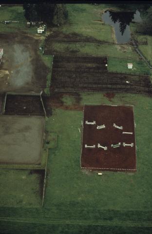 An aerial, color photograph of deserted pasture land. Artifacts like horse trailers and equestrian fencing suggest the imposed use of the land.
Citation -
3. [Image] Lower Klamath Lake
KP-2276 - Klamath Project--Lower Klamath Lake. Viewed north from point directly west of outlet portal of Tule Lake Tunnel showing P-1 Lateral in right background and privately-owned farm lands; April 12, ...Citation -
4. [Image] Lower Klamath Lake - Viewed from northwest
KP-2282 - Klamath Project--Lower Klamath Lake. Viewed from northwest showing Klamath Straits Drain and Klamath Drainage District lands with Lower Klamath Lake in right background; April 12, 1956; Photo ...Citation -
KP-2284 - Klamath Project--Lower Klamath Lake. Viewed from just southwest White Lake, showing agricultural lands (Fish and Wildlife Service) in foreground, and Refuge Sumps 4, 6, and 7 in center; April ...
Citation -
KP-2285 - Klamath Project--Tule Lake Division. Viewed from just north of Tule Lake Sump 1, showing sump with farm lands in foreground; April 12, 1956; Photo by Tom Horn
Citation -
KP-2286 - Klamath Project--Tule Lake Division. Viewed from just west of Tulelake showing Tule Lake Sump 3, with farm lands in foreground and at left; April 12, 1956; Photo by Tom Horn
Citation -
P-12-200-4235 NA Klamath Project, California-Oregon. This dam diverts water to serve lands in Langell Valley. It is an earth embankment with a concrete gate structure, 18 feet high and a crest length of ...
Citation -
P-12-200-4242 NA Klamath Project, California-Oregon. Diversions at this dam are carried in "J" Canal to serve lands if the Tule Lake Division. It is a reinforced concrete slab and buttress type, 23 feet ...
Citation -
P-12-200-4243 NA Klamath Project, Califorrnia-Oregon. The Dam is a concrete weir, removable crest, embankment wing type structure, with a height of 5 feet, and a crest length of 290 feet; September 29, ...
Citation